
PCT 2018: Days 112-116, White Pass to Snoqualmie Pass
Photos and stories from my thru-hike of the PCT. This post covers days 112-116 from White Pass to Snoqualmie Pass, mile 2,270-2,390.

August 24, Day 112
~19.5 miles [2295.5]
Not an ideal night. Rough and windy, I was awake for most of 11-2 A.M. hours with a billowing rain fly. Summoned the courage and removed the fly, then took a horrendous dumb under an almost blinding full moon, fully engulfed in a bank of clouds. Managed a little sleep before giving up. Sunrise was completely shrouded by fog and clouds, I couldn’t see ahead of me more than 50 feet except for a brief five-second window. “Shocks” and “Tumbleweed” weren’t lazy (also they were the only ones who camped higher than us) and got a photo, I didn’t even touch my camera. Big shame. Got to Coyote Junction, mile 2278.6, and started down Packwood Lake reroute. It felt like 15 miles of steep descent which took us from 8-1 P.M. Stumbled into the trailhead and got a lucky hitch inside a horse trailer who’s cargo was an ATV, two motorbikes, and two blonde girls also hitching. I think that was the oddest ride so far. Went for coffee and it looked like “Roadrunner”, “AutoPilot”, and “Colonel Sanders” had made it down and shared the same idea. Americano never tasted better. Hitched to White Pass, “Sticky Fingers” and “Brownstreak” showed up. Picked up our resupply box from the Kracker Barrel. “Stick” gave me his vape pen battery, “Tumbleweed” gifted me her concentrate pods, and “Shocks” gave me his headphone dongle! THE TRAIL PROVIDES! Nearby apartment was offering free chili. I washed it down with a microwaved burrito. Picked the trail back up at mile 2294.9 and got about a mile out before setting up camp. Velveeta dinner—the tenth and final portion of that meal—and another beer. Shared camp with “Cray-Nip”. The border is closed and I am thoroughly bummed. I didn’t do this trail for the border alone but I feel horribly cheated if I can’t cross.
Packwood Lake, Washington.
White Pass and Highway 12.
August 25, Day 113
28.2 miles [2323.7]
Nearly fell asleep before writing, I think I knocked out from 8-9:30 P.M. (I refuse to miss any entries). Chilly morning, I wore my rain/wind jacket most of the day. Passed by streams, creeks, and ponds of varying hues. About the time when afternoon clouds burned off it began raining and everything became damp and miserable. All my gear is wet, but not soaked, except for my quilt and sleep clothes. I spent a lot of time worrying about the consequences and how I’ll stay warm but I know I’ll learn as I continue. Lunch break at Bumping River and “Sticky” angled with his Tenkara. “Brownstreak” looked tired. Dense fog and mist swaddled me like a comforter made out of depression. Got to Chinook Pass and hunted for a suitable site just as the hypo began to set in. Hastily made camp and hung out in my tent with my remaining dry layers and ate a shit ton in an attempt to warm up. Somewhat concerned about tomorrow since it’s not going to be any warmer or drier. Cross that bridge when you get there. Just. Keep. Moving.
Pipe Lake, mile 2302.5.
Tipsoo Lake Junction near Chinook Pass.
August 26, Day 114
23.3 miles [2347.0]
Very fortunate to have slept warmly. Commanding/summoning the motivation to hike was brutal. It was probably 48 degrees and anything which wasn’t inside my tent was completely soaked. Pulling on wet pants is a depressing way to start anyone’s morning, I wasn’t a happy camper. Squished into my shoes, at least wool socks mitigate the misery. “Shocks” only groaned when I wished him well, he eventually caught up in the afternoon. It threatened to get warm but never actually did. “Sticky” and I hiked together for a while before taking a 20-minute snack break. No one could sit longer or else they were going to get too cold. Kept moving just to keep my body working, it seemed. Drank my only packed beer for the illusion of warmth and happiness. Trudged and trudged until there was a clearing in the fog and I saw the Mike Urich cabin. Comments made it sound like the place would be rife with non-hikers but much to my luck and amazement the tiny ski hut was being run by more than a dozen hikers. Cold, wet, dehydrated to the point of thirst, and in caloric-deficit, I guzzled a liter and crammed a ton of snacks. There was a fire in the wood stove and suddenly the entire room felt very smoky. I felt hot. Went outside on the porch and got fetal (where it was 48 and drizzling) took off my puffy and started breathing like I was a first-time passenger in an overactive F-16. “Miraj”, I’d never met him before, kept an eye on me and brought me water—the hero we all need. Ten minutes later, as rapidly as it had come on, I was back to 95%. “Sticky” was a generous god and gave me a bite of his cinnamon toast and cookie butter sandwich. Inspired, I took the remaining tablespoon of communal butter and bread heels and whipped up a beurre noisette for my grilled cheese. Fat is king. Foggy views through the burn area were ghostly and mysterious. Pure Washington. Going to be challenging to get good sleep but it has to be better than camping out in the wet.
August 27, Day 115
23.8 miles [2370.8]
Not terrible sleep considering claustrophobic cabin circumstances, I only woke up a few times. Took some rips from “Beehive” and “Miraj” gave me an IPA. Ate a few of the remaining communal bars on the table and set off into the dull and dreary world, word was clear skies around noon. Trudged through seven miles of haunting fog and finally it cleared and I saw the sun. Rejuvenating and life-affirming, I felt happy. My soul was warm. Clouds are the best for hiking though, gray mist is good for nothing. Dried my tent out and saw “Brownstreak”. Took lunch at the stream with “Taco” and “Cray-Nip”. Lots of little dirt road crossings today. I wonder how they got there? Wandering thoughts turned to Breckenridge and upcoming photobook. Shared camp with a guy named “Croissant” on one of those nameless and unused roads. I’m certain I lost my beanie yesterday which is a total bummer, I’ve had it since my first summer camp over 15 years ago. I suppose it’s just another material item. Looking forward to Snoqualmie, perhaps I’ll get the pancake breakfast and a hotel/hostel. Tired of hiking but it’s still enjoyable, I just feel depleted. Nearly there. Relaxing evening in the tent.
August 28, Day 116
23.4 miles [2393.2]
Aardvarks “Hurry Curry”, in Snoqualmie; an explosion of nearly-forgotten flavors.
Enjoyable hike which was mostly full of hills. Psyched myself out about some inclines, but overall, very doable. Low on food but I knew about town and resupply. Ran into “Taco” and “Miraj” and we cruised under the lifts and down into Snoqualmie. Found some trail magic just before town. There was a food stand called Aardvark Express which served a very highly regarded “hurry curry”. Ordered one and was thoroughly amazed, so many flavors like long-lost friends I thought I had forgotten: cardamom and cinnamon chicken curry over rice with pineapple cornbread, cilantro, spinach, green apple, and spouts, a one-and-a-half-pound flavor masterpiece. Free Rainier beer to wash it down. Did a stealthy load of laundry at the Inn and emailed my references for housing. Picked up and sorted out resupply, bought beer, and road walked to the Alpine Club. It was an eclectic chalet with local mining and skiing memorabilia strewn about the stone and wooden walls. Very cool except for a skeevy old guy who is the on duty manager of the house, the kind of person who thinks he manages the universe. One of the loquacious and stronger-willed hikers got confrontational later in the evening; being a bum in the woods can have an impact on one’s self-confidence a little too much. Tried to stay clear and took a legit shower with a beer. Electricity and new friends meant we all stayed up late—a flameless campfire. Had a nice chillout with “Cray-nip”, “Doobie”, and “Miraj” outside with good laughs and more Rainier. Midnight snack of fine salami, probably left over from other hikers, I must remember to eat more tomorrow...with eggs.

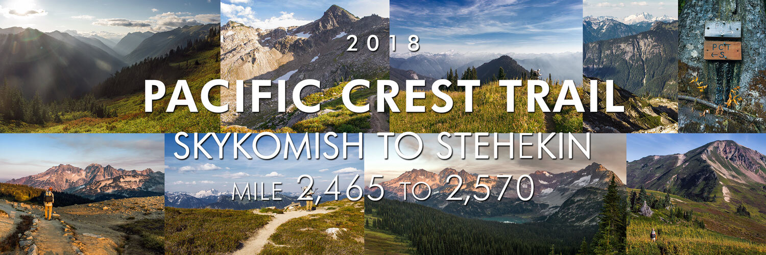
PCT 2018: Days 121-126, Skykomish to Stehekin
Photos and stories from my thru-hike of the PCT. This post covers days 121-126 from Skykomish to Stehekin, mile 2,465-2,570.
September 2, Day 121
12.4 miles [2476.6]
Rough night at the Dinsmore’s. Trains ran by what seemed like every hour, plus, being well hydrated with beer and water meant an out of the ordinary witching-hour piss. “Shocks” woke me at 8:30 A.M., he and “Gandalf” were almost packed. Jerry wasn’t up and around to thank which was a little disheartening, I can’t see this place being around much longer. Caught a hitch out with a current trail work volunteer “Spider” who was a part of rebuilding the brand new (and freshly re-opened) northern terminus monument. Hopped out at Skykomish and headed to the Cascadia Inn for brunch. All you could eat, I filled up on scrambled eggs, sausage and crispy bacon, hash browns with biscuits and gravy, plus fresh fruit; watermelon, pineapple, and strawberries. Coffee with real cream. The meal made up for more than one rainy day. Made a hasty sign and tried to hitch, eventually we ended up sweet talking a couple fueling up. Got to Steven’s Pass and “Shocks” gave a short phone call to the parents, then it was time to hike. On the way towards the trail we saw “Trash Queen” and “Penguin” trying to get the same challenging hitch from the highway. We hugged and caught up, looks like we all want to end on the same date. Hopefully we can meet and celebrate at the terminus. The weather was absolutely sublime. Saw a shit-ton of weekenders, many of whom congratulated us, it’s hard to contain my excitement when I tell people I started at Mexico. I felt unbelievably stoked and proud. Clear and cold night, no fly to watch the stars. Moments of anger about the Ranch, only because of Facebook. Who cares, move on.
September 3, Day 122
23.6 miles [2500.2]
That was the last flyless night I ever try in Washington. At 3 A.M. I woke to some cold sprinkles on my face and scrambled to put on my cover. Got a little more sleep and started moving by 8:30 A.M., snarfed a Pop Tart with butter. Stoked to hit the 2500 milestone. My nose has been constantly leaking in this cool weather. The forest is alive with color, rich hues of rust, umber, and olive. By the afternoon it had cleared up to reveal lots of nice clouds, a good reminder of how much time I spent without them, the sun and warmth felt wonderful during snack breaks. “Larry Bird” spotted a porcupine, I’ve never seen one in the wild before. It looked as though some quills were missing, just a little bedraggled. “TQ”, “Penguin”, and “Bear Can” caught us and we all shared camp at Reflection Pond. They are all aiming to finish on the 10th and doing 28 tomorrow, I’m not about it. Hopefully I see them again. Tuna taco with pepperoni and Cheetos. Remember to make your food last three days.
September 4, Day 123
25.4 miles [2525.6]
Restful slumber until “Trash Queen” and “Penguin” packed up, they left at 7 A.M. and we left an hour later—not in any rush. It was exceptionally gusty but a decent hiking day with more huge ups and downs, the last decline was 3,000-feet in five miles. Not a single flat section, the terrain was brutally technical with lots of rocks. Traversed a few miles which couldn’t have been the actual trail, just dozens and dozens of hikers making the same mistake at a hidden junction which wore in a new and more recognizable path. The tread was at an ankle-breaking angle with gnarled bushes and roots which clawed at your toes. During lunch “Shocks” was doing a poor job of holding back tears, offering no response. We trudged on. Just when I thought I was finished with the last hill, Milk Creek was full and didn’t have any available campsites which feels like my fault, of course they would be all taken, the spread of sites is stupid. The terrain is garbage. Looked at the map and started freaking out about another five mile incline as dusk was rapidly approaching. By the grace of St. John and his random pit toilets, there was a small clearing for a random pooper about a mile ahead which had barely enough room for three tents. We set up and made room for a third which was later filled. During dinner, “Shocks” briefly mentioned he was having a hard time with being finished. We sat quietly, not saying anything. I don’t feel the same currently but I know I will—I’ve always been that way. I’m going to miss this, deeply. Looking forward to the future, however, the present has been fucking sweet.
Fire Creek Pass, mile 2520.
White Mountain and White Pass, mile 2502.
September 5, Day 124
27.2 miles [2551.8]
Slanted sleep, then a precarious poop less than 20 feet away from my tent which was my only unfavorable choice on location. Lathered up another Pop Tart with butter and began moving. Today’s terrain looked like a cross-section of a collapsed souffle, the final hill was a steady eight miles. It’s hard to silence the part of my brain which dreads hills, however I know I’ll be over and through it soon—a lesson on life. I only have one day of food remaining, not a half-day more, which has me slightly stressed. Guess I’ll have to snack-up at Holden Village. Low on podcasts once again and a wandering brain doesn’t feel good to have at the moment. Knees and legs are sore tonight. Our campsite is killer, we’re right on top of Cloudy Pass which is part of the fire reroute, alpine peaks in a smoky haze have me right back in the Sierra. Fought off more negative thoughts about the Ranch—not ideal. My lacking food situation makes it tough to stay positive. Big day ahead tomorrow, it’s all “off-map” which is going to be fun. Took a page from “Shocks’” cook book and made a Cheetos and Oreo peanut-butter-and-butter taco. He’s definitely on to something.
Dumbell Mountain and Lyman Lake from Cloudy Pass.
Dolly Vista Trail Camp, mile 2532.
September 6, Day 125
~21 miles [2551.8]
Warmer than usual morning which had me hiking by 7:15 A.M. Absolutely stunning terrain, hard to imagine how much great trail is out there we otherwise would have never seen. Low on food, I was coasting on fumes, drinking water to fool my gut. Arrived at Holden village and missed the morning ferry by five minutes which left us with the option of waiting a few hours to take a $10 bus and an $8 ferry or hike out, both seemed to be the same amount of time. The lunch meal choice was a vegetarian sandwich which also didn’t sound like a great value for money. Somewhat dejected, I bought a few candy bars to chase my Clif bar and followed “Shocks” to the trail. Made it over the hot and hellacious Hilgard Pass which had to be more than six miles and was rewarded with downhill for the remainder of the day. Got to a large river crossing at dusk where there were a few other hikers attempting to find or make a suitable campsite. On the crossing I promptly plunged my foot into the current—mistimed my jump. “Shocks” and I eyeballed the topo and he voted to bust out the last four miles in the dark but my money says it was closer to six, plus, it’s not PCT-grade, we could have gotten a nasty, unknown surprise. Found the flattest ground with the least amount of rocks and made camp. Savored my last tuna taco with a handful of dusty and broken chips along with a package of M&M’s. It’ll work but I’m definitely hungry. Stoked for the final resupply, I think there’s one gnocchi meal remaining.
Lyman Lake and Dumbell Mountain.
September 7, Day 126
6.5 miles [2571.8]
Uncomfortable setup as my back later revealed but I slept well nonetheless. Up and moving by 7 A.M. with my puffy for about two miles, it was shady and cool. No map-checking so I took what came to me. Cruised six miles or so to the road (definitely more than four) and made a quick assessment: go to the bakery. Devoured a pesto, onion, and Swiss croissant pocket which was a sincere 9/10, lots of coffee too. Caught the free shuttle to Stehekin and was blown away by the waterfront of Lake Chelan—chill vibes, gorgeous sun. Saw “Brownstreak” and “Miraj” at the lodge! Sat and talked, drank two beers, and went through our final resupply box. Also managed to download two podcasts on their slow network. Picked up a permit for zero miles which seemed to bum “Shocks” out, but I knew “Panda”, “Doobie” and a few others were gonna stick around at the bridge. Shuttled back to the bakery for a bacon and onion quiche and I got suckered into paying $3.50 for a root beer. Caught the bus for High Bridge Ranger Station with a few other hikers. Rain is in the forecast and certainly threatening at the moment.
Crossing Stehekin River.
Lake Chelan plane.
Hike On?

PCT 2018: Days 127-130, Stehekin to Canada-USA border
Photos and stories from my thru-hike of the PCT. This post covers days 127-130 from Stehekin to the Canada-USA border, mile 2,570-2,652.

September 8, Day 127
27 miles [2598.8]
Had a hard time falling asleep which is rare. The threatening rain had turned to wet clouds, we hit the trail around 7 A.M. and I ate a Probar. Very long but not exceptionally strenuous 20-miles uphill to Rainy Pass was easy enough. Elon’s interview was a pretty fun distraction. Had a cool and quiet lunch break before the pass; peanut butter on day-old biscuits and jerky with Nutter Butter dessert. Drank caffeinated Mio like I was dehydrated in the desert. Met “Skaggit Ed” at Highway 20 and he had magic. He handed me an IPA and some amazing fudge. Did a few miles with “Panda” before the pass. It’s another cold night, there’s snow in the forecast. I’m not worried, rain is by far the hardest challenge. Cooked a jambalaya as best as possible and followed it with a Snickers. Started a list of things to do at home before moving to Colorado. Trail was quiet today, didn’t see many people. The end is on the tip of my tongue.
Cutthroat Pass.
September 9, Day 128
24.7 miles [2622.0]
Brisk morning, rolled out close to 8 A.M. and headed for Methow Pass, shoveled Mojo bars into my mouth like coal into a locomotive. Harts Pass is closed northbound for a few miles which makes this our third reroute (I think). Listened to The Avett Brothers interview for the fourth time. It was cloudy all day and threatening rain, a typical sight. Spam and cracker lunch just as it began to drizzle but fortunately it never developed any further. Saw “Panda” and his pops at Hart Pass and learned his real name. They spoiled us and he let us raid all his extra food supplies, we took chicken and candy. Leapfrogged “Butters” and “Hot Mess” and I finally remembered their names without having to ask again. Man, I think we first saw them in the desert. “Shocks” and I smooshed our tents together and cooked in between the vestibules—chicken and noodles. I’m so unbelievably close to being finished: I want it so bad and not at all, at the same time.
September 10, Day 129
~25.1 miles [2644.3]
It’s my last night on trail. I woke up at 4:45 A.M. to light sounds of rain, like the crackling of fading fireworks. Tossed and dozed for four hours and finally got the gumption to pack. It was drizzly and wet most of the day, I spent the first four miles in the puffy and rain jacket, I was actually cold. My pants soaked up all the moisture from the overgrown brush. Kept putting one in front of the other, I ran out of podcasts and music long ago. Saw “Panda” one last time, saw “Brownstreak” one last time; they’re headed back to Harts Pass. Saw quite a few people I’ve met over the past few days but never took the time to officially meet and learn names. My hands were numb most of the day, feet pruney from wet socks. It’s currently raining and I need to pee. Tomorrow, I will become a thru-hiker. It’s taken over a year and more than what I spent on my car, probably 3,000 miles and almost more nights camping in a tent than my entire BSA career. There’s so much more to do, I’ve only just begun.
September 11, Day 130
16.3 miles [2652.6]
“Shocks” and “Tiny Slice”, PCT northern terminus.
My last cold start. Woke up, wide awake, at 4:30 A.M. thinking about the last day. Put on all my layers once again and got moving. My knee panged throughout the night and hiking certainly didn’t improve my condition. In some weird turn of events it was the only thing I could concentrate on. Less than nine miles to the monument and then I saw it—and felt nothing. When I went to pen my name in the log book I was trembling, my entire body welled up like I was going to implode—I made it. Celebratory joints with “Beehive”, “Cray-nip”, and “Feather”, “Shocks” surprised me and pulled out a small bottle of Jack. Also at the terminus was “Roadrunner”, “AutoPilot”, and “Colonel Sanders”. Everyone congratulated each other sincerely, we are the only ones who know what we went through. Time to leave, no sense in lingering it seemed. Hike to Manning Park was rough, I limped the whole eight miles. Got to the cafe and drank the as-advertised free coffee with as much cream as they would bring me. Hardest hitch was the final one, but after an hour of looking hopeful on an international highway near a border, Ramayaan was our savior and picked us up and drove us to Coquitlam, more than 100 miles. Starbucks for internet and a quick and dirty A&W burger (not worth it) before we figured out a metro train into Vancouver. Mistimed our transfer train and it took us a few tries of hopping off and on to figure it out—it’s so much easier to correct your mistakes at walking pace. No hotels, so we bought a 6 A.M. flight on our phones. After walking an extra block since we couldn’t remember where we got off, we took the last train into the station. Bought a Canadian Wendy’s burger and set up a makeshift camp in the lobby and got our packs ready for tomorrow. Today? It’s 2 A.M.; I’m a fucking thru-hiker.
The border.
Hike On?

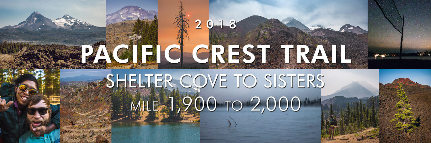
PCT 2018: Days 96-99, Shelter Cove to Sisters
Photos and stories from my thru-hike of the PCT. This post covers days 96-99 from Shelter Cove to Sisters, Oregon, mile 1,900-2,000.
August 8, Day 96
31.2 miles [1938.3]
I can’t believe I slept until 6:15 camped next to four other people and still managed to be the first one out of camp. First seven miles ahead, then I took a nice hour-long break at Maiden Peak shelter; I think I waited 30 minutes before “Brownstreak” sat down and ate a thawed microwave-burrito. It felt hard to find or make motivation, yesterday’s diet certainly did not help. Caught wind of trail magic at Charlton Lake and suddenly forgot about my sluggish woes. “Ducky”—2-for-3 on the trails—and his dad were super eccentric and holding court with at least six hikers. There were a pair of ladies, Hannah and “Sparkles” who were much more introverted and manned a grilled cheese station. I was lame and didn’t really chat much with our hosts past the usual profuse thank-yous, everything hurt and all I could see was food. Both parties were beyond well-equipped and more than a dozen hikers sat and ate to their heart’s content. I had two grilled cheese with fresh tomato and pickle toppers, Doritos and choc-chip cookies, plus a Coke and two IPAs. There were Ben and Jerry’s pints(!) but “Sticky” and I were stuffed once again and chose to split a Cherry Garcia. Pack on, waddled out, and found a pace and cranked miles out, passing dozens of scummy ponds between massive meditative lakes. Didn’t see anyone else and only two hikers passed me. Dusk set in and I thought I was behind, the trail was smooth, and I was angsty so I ran the last three in under a half-hour. It got dark and I set up—it’s officially my first night alone. It’s boring, nice, sad; I’m tired and proud. The mosquitoes at this lake are savage but I’m safe in my tent sanctuary just like everyone else.
August 9, Day 97
27.5 miles [1965.8]
All-over, a hard day. Good sleep after 10:30 P.M. once the few other late hikers settled in—looks like I didn’t camp alone after all. It also turned out camping by a lake meant no respite from mosquitoes and I packed in a constant orbit around my camp, never pausing to get bit. Hike was hard despite an easy downhill morning, I think I had strained a few ligaments on the arch of my left foot from last night’s panicked run to catch up. Thought a lot about being behind and how I just managed to reconnect with “Shocks”, I worried about being on my own once again. I thought I beat this? It was a hot afternoon and I found a decent stream in the shade which was a good excuse to wash socks and deduct 12-ounces of beer weight—I chilled it in the stream while scrubbing. Hot afternoon and being sore didn’t help. Turned out I was ahead. “Shocks” caught up and we took lunch, salmon taco, and split my other beer. The last few miles were pretty nice; South Sister is straight up epic and Mt. Jefferson looks dope—I’m ready to ski. Filled up at an extremely milky creek which filtered clear, don’t want to think about what it did to my filter. “Lost Dog” produced a quart-zip stuffed with bud from a trail angel and offered me a handful. Dinner was Velveeta salsa mac, then we set up in the meadow. “Conflicted” and “Sassy-K” said they both struggled; today’s terrain was tough and we all agreed it probably had something to do with the lack of views despite the last few spectacular miles. Out of spare power and it’s stressful, but it’ll work out. Less than 40 away from the 2K milestone—in under 100 days!
August 10, Day 98
30.1 miles [1995.1]
I must have set up on a queen mattress; the meadow grass and cold, wet air made for a glorious night of sleep. Another challenging day but the views more than made up for it; sparse, tortured trees, expansive meadows, streams and rocks, I would hike Oregon again for this stretch alone. Took a lengthy break at Sister Spring. “Conflicted” was a constant stream of gender pronoun jokes and I was nearly brought to tears with laughter; the best kind of breaks. Obsidian Falls was a nice surprise. Arrived at McKenzie Pass later in the afternoon and found a magic cache which had Doritos, Coke, and the juiciest, best peach of the entire season. Spotted “Coppertone’s” tell-tale RV and got a root beer float and took a nice sit. Nobody was stoked to figure out there were 13 more through some treacherous lava fields for a reliable camp. Found the courage to leave and struggled the entire time, each step pinched and stabbed, sharp rocks tenderized my poor feet, I would have rather walked through a pit of gnashing crocodiles. Rewarded, almost on a spiritual level, with a fiery sunset who’s rusted hues from smoke backlit ghostly, bone-white trees. It might well have been Mars. “Brownstreak” and “Shocks” caught up and we stumbled into Big Lake Youth Camp as the last bit of light vanished. I was immediately reminded of Philmont, all summer camps have a similar vibe: cute overall map, dining hall and meal hours, and someone who invariably exclaims “Hi, welcome to camp!” in a cheery and effervescent tone which borders too closely on psychosis. Directed to the “hiker area” and “Shocks” and I settled on a beach outcropping with a volleyball net. The sand feels great but I know everything will be soaked tomorrow morning. Oh well.
Mount Washington Wilderness and the Three Sisters.
North and Middle Sister.
Big Lake Youth Camp by stars.
August 11, Day 99
9.7 miles [2002.3]
As predicted, I woke up soggy on the volleyball sand near the water’s edge, a wall of low fog obscured the opposite bank of Big Lake. Huge windfall to have the hiker hut open a full hour earlier than posted. The shower I scouted yesterday was empty, no towels were hanging up, no one was loitering; I snagged the first one. Split a load of laundry, fueled up on coffee, and responded to the renter’s application. Ate at the dining hall and heard the clamoring of rowdy chow-hall kids and could feel myself drifting back to camp. I’m happy where I am but I can’t help but think about another summer, perhaps that’s always going to happen. Untoasted bagels two-ways; butter and tomato, then cream cheese and raspberry jelly followed by fresh strawberries and watermelon chunks and a side of yogurt made for a complete breakfast. Fully charged and clean, “Streak”, “Shocks”, “Conflicted”, and I headed a measly six miles to Santiam Pass, despite being offered a ride—everyone’s mood seemed to be in a hiking spirit. Crossed mile 2,000! Almost had a difficult hitch into Sisters before a pickup picked us up, I managed to konk out on the highway, wind and hair whipping me deaf in the bed. Hitch took us two miles too far which was stressful for “Conflicted” and I let him wind me up, plus it had been a few hours and miles since anyone had eaten. Found a lunch spot and had a chicken-bacon-brioche number with a 10-outta-10 habanero hot sauce (Aardvarks) and waffle fries. Used their free wifi and refilled my podcast feed. Temporarily sated, we made our last resupply for Oregon. Managed to reconnect with Sam Anderson and also got a surprise call from Pete Bergene. Hard hitch back to trail but I know now it always works out, easy to remember two beers deep dancing with my thumb outstretched on the side of a highway on a warm summer’s night.
“Brownstreak” and “Conflicted”.
Hike On?

PCT 2018: Days 105-106 Cascade Locks and PCT Days
Photos and stories from my thru-hike of the PCT. This post covers days 105-106, Cascade Locks, Oregon and PCT Days.

August 17, Day 105
0 miles [2146.8]
First time in my life I was up at the same time as dad in a hotel room. We went to the continental breakfast and had a nice conversation about winter living, moving, and possible future trails. Went to Multnomah Falls, it was slam-packed—a big tourist attraction—pavement everywhere, and felt busier than Yosemite in late June. Picked up a resupply at Grocery Outlet and Dollar Store. I was fairly stressed, too much coffee didn’t help, and the stores were vibrating with a raucous din. Got the essentials and repackaged. Made a detour by Bonneville hatchery and saw Smart-car-sized sturgeon. Remembered what Rinella said about anadromous and catadromous fish types, something I never would have retained in school. Swung by PCT Days for an hour and a half, there was simultaneously a lot and nothing going on, plenty of expensive gear I shouldn’t buy. Had a pint at Thunder Island and a smoked salmon spread, a reminder that tuna tacos still leave much to be desired. Checked into the hotel and went out for BBQ dinner which was bar none and hands down the best any of us had had in recent memory. Parents bought us our own room tonight. Smoked one and only joint with “Shocks”, then watched Oceans 11 and Rush Hour until well past hiker midnight. Anxiety into alleviation.
Multnomah Falls during a very busy time of year.
August 18, Day 106
4 miles [2146.8]
Today was a whirlwind of fun, I’m so glad we turned back! Another hotel continental breakfast and good conversation with fam. Packed up and drove back to Bridge of the Gods and our parents walked across with us. It’s always hard to hit the trail after a zero. Warm, humid, and with everything freshly washed, we began hiking. Got about two miles out and received two phone notifications from friends in town. Bruce was visiting and Mitchy had somehow caught up. Sat on the side of the trail fraught with indecision to keep hiking or turn around, I think we were both looking for the other to make the move. I’ll give credit to “Shocks”, we turned back and it was such a monumentally great decision. Hung out with Bruce, got free Alehouse pizza and a $2 PBR with all the other hikers who made it for Trail Days. Saw tons of acquaintances and friends including “Panda”, Darby (who informed me she accepted my offering as “Dirty” for a name), Mitchy, “Conflicted”, “Sticky”, and “Dutchie” who had miraculously received my pen parts and delivered them to me, huzzah. Drank all day, even the brewery was giving out free pints for hikers. Bought a salad and more beer for my last snack of the day. Sunset on the Columbia River was fantastic and I took my camera out until dusk. There must be 500 tents set up on the island. Going to be a hard night of sleep, but no regrets at all. A great ending to a first double-zero.
The world’s happiest pooch.
“Odin”, a US veteran.
“Sassy-K, Inchworm Sr.”
Sunset over the Columbia River, Cascade Locks.
Hike On?

PCT 2018: Days 60-61, South Lake Tahoe and The 4th of July
Photos and stories from my thru-hike of the PCT. This post covers days 60 and 61 in South Lake Tahoe, mile 1,090.

July 3, Day 60
0 miles [1090.0]

Note to myself (and others): while getting cross faded at 7:30 A.M. feels amazing and bubbly, it will never lead you anywhere photographically. This was the only photo I took that day.
No one was in a rush to get out of their tent. As we packed “Trash Bath” waltzed around and handed out yesterday’s pot cookies. Not long after, “Streak” came back from the store and passed out pounders. It was a fantastic morning. Made tracks to the grocery store for breakfast and a plan. Got a freshly toasted bagel from the bakery section and “Shocks” and I split an entire eight-ounce block of cream cheese. Had coffee for what feels like the first time in weeks. Interneted hard and stressed over the newest map section. Someone discovered there was free food for thru-hikers at a nearby restaurant and it seemed like a worthwhile investigation. At Base Camp Pizza I met “Gula” and “Gabe”, two young guys with a limited break from the Air Force. I made sure to drag my fingers through the bowl my bacon-jalapeno Gouda mac was served in and enjoyed the blissfully idyllic weather shaded by an umbrella I didn’t have to carry or hold. Back to the grocery store where I finally cobbled together a resupply. It cost way too much—$82 for 120 miles. Got a free ride to the Post Office from an Uber driver who took one look at us and pulled over. While buckling he told us he had a friend who hiked the AT, suddenly we were having a conference call in an Impreza. “You’ve already made it, make sure to enjoy your time,” he said, almost as if he had rehearsed this message before. Slapped on the correct postage and said a cheery good riddance to my bear canister which has to be the easiest and most emotionally charged two-and-a-half pounds I’ve ever lost. Even with a fresh resupply I feel lighter on my destroyed shoes. Gang reconvened at the beach for low-key beers. I swam for a total of three minutes, long enough to break up the dirt and grime layer. While the gang sunned themselves I watched a wedding photographer politely haranguing 25 family members into new poses, busting his ass without an assistant to move the monolight, unadulterated Schadenfreude coursed through my buzzed body. As the sun set we hit up McDonald’s for the third time in two days, a haven for last minute snacks and internet. The place was packed with festive high schoolers unable to contain themselves with the impending holiday. Found a good spot to stealth and set up our encampment near the ski resort. Zero’s are legendary with friends. So unbelievably stoked for the 4th.
July 4, Day 61
17.7 miles [1103.2]
Peaceful night behind the residential area. Packed up and retreated to Mickey D’s for breakfast and a hitch out. Didn’t want to eat my trail food so I got two hash browns and two sausage burritos plus a coffee. I probably could have made a valid argument for being awarded the senior discount from the mileage on my knees alone. Tried to hitch for over 45 minutes, my longest attempt so far. I was losing faith and seriously considered walking when a man with clear oval frames sporting a scarf over his tie-dyed dancing bear T-shirt approached us. “Grateful Dad”, father of “Vinyl” (who gave me my trail name), was headed to Grocery Outlet and asked if we needed any help. Beaming, we hopped into his van. “Trash Bath” bought four eight-count boxes of Firecracker Popsicles which were gone by the time we parked at the trailhead. Profusely thanked our sandeled Angel and loaded the new map. “Sticky Fingers” grew up here and had a plan for our day. Must have passed more than 50 other day hikers in the six miles it took to get to Lake Aloha. Set up lunch on top of a 25-foot boulder with a shear drop-off facing the water. I watched all of my friends casually backflip and gainer into a seemingly shallow lake. I thought about the phrase I write in every trail log I’ve signed: 1) go fast 2) commit. It took some encouragement, but upon standing I made good on my axiom. The plunge made my dollar cherry pie all the more sweeter. Hiked on to Gilmore Lake near the base of Mount Tallac. Made camp, devoured a tuna taco, gathered all my layers and alcohol, and scrambled to the top just in time for sunset. A bottle of Fireball was passed around in an attempt to block the unyielding wind as dusk turned into twilight. I counted five distinct firework shows scattered around Lake Tahoe’s rim, the Milky Way silently stealing the show. Survived a fairly treacherous and pitch-black drunken Class 2 scramble down to camp. Forgot about the Ranch—even for just a moment.
“Sticky Fingers” jumps into Lake Aloha.
Cherry pie on the 4th of July.
“Combo” celebrates his freedom.
Mt. Tallac’s shadow.
Lake Tahoe at dusk.
“Sticky Fingers” and Lake Tahoe
Hike On?

PCT 2018: Days 71-75, Belden to Burney Falls
Photos and stories from my thru-hike of the PCT. This post covers days 71-75 from Belden to Burney Falls, mile 1,300-1,420.

July 14, Day 71
31.8 miles [1331.3]
Today was exhilarating; always say “yes”. Peeped a little of the sunrise through my mesh door. Mobbed another 30 miles and my feet are beat, I generally ache. There was a 15-mile haul between water sources, the few options there were didn’t seem promising. Little Cub spring was 1) off-trail and 2) a gnarly 200-foot decline to access but at least it was ample. Regrouped on trail and ate first lunch with “Tooth Fairy” and “Upstream”. Hit the halfway point but honestly, it felt totally hollow. I remember how motivating the first 100-mile marker was in the desert or seeing the “10%” pile of rocks or getting the clap at Kennedy Meadows, but California is so long, it doesn’t feel like an accomplishment. Either way, we ate second lunch and came up with a plan for Chester, both agreed to go in tomorrow. Continued hiking downhill and wound up at the highway, plans be damned, praying for a hitch as dusk settled in. There was one promising lead for a Trail Angel who provided rides: “John Jacobs, I’ll try to give you a ride if you call me. I’m Chesterite ‘born and raised’”. An animated, fast-talking man soon arrived in a mid-90’s Acura Integra, miraculously the three of us squished our gear and stinky bodies inside. The entire ride into town was filled by John who, in the friendliest and most disarming way possible, told us the horrors of the judicial system, grow laws, and persecution he’s faced and evaded due to his self-proclaimed extensive knowledge of the law. He kindly dropped us off at Pizza Factory where Adam and I split a large garlic and chicken ‘za and a pitcher of domestic. Full and slightly buzzed we packed up and headed for the Lutheran Church to make camp. Upon approaching an intersection with a gas station, there appeared to be a man taking hot-laps around the pumps in a mobility scooter, the tail of his coonskin hat being lifted ever so gently by his modest speed. I looked away as to not draw any attention and crossed the street. Before the three of us had gotten halfway across, the man whizzed towards us, yelling “CITIZEN’S ARREST, CITIZEN’S ARREST” at the top of his lungs. It was 10:58 P.M. My heart was in my throat but after he slurred a few sentences, I realized he was completely hammered and bragging about his scooter—a gift for his infirmed father. “Shame you hikers don’t have beer or weed,'' he mumbled, changing topics drastically. “But at my house we do. Follow me.” He zoomed off into the night, tail following just behind. The three of us stood silently, realized we outnumbered him and had quite literally nothing to lose, and followed him. We ended up in his backyard where he promptly tossed us each a Bud Light and sparked a joint. The mosquitoes feasted on my thin blood but all I could think about was the kindness of strangers and the lengths people go to for camaraderie. He gave us his phone number and emphatically reminded us we had a job (growing related of course) whenever we wanted. I thanked him for his kindness and made one final comment on his savvy scooter purchase before we stumbled to the church. Chester is hella weird.
Lassen Peak.
PCT midpoint. Hurray.
July 15, Day 72
11.4 miles [1340.7]
I woke up slightly before 5 A.M. with an odd, cold sensation on my face and I heard other tents rustling, then my lucidity arrived. It was beginning to rain, the entire PCT population of the Chester Lutheran church were furiously scrambling to throw on their flys, everyone unprepared from last night’s clear skies and muggy temps. Went to Kopper Kettle with “Conflicted” and “Tooth Fairy” for real breakfast: endless ceramic beige mugs of cheap coffee—a constellation of creamer cups filled the table—with biscuits and gravy. I’m stressed about this section and it seems the majority of hikers are as well. My shirt is toast, it lasted more than a thousand miles and is ripping apart from the shoulders. Dollar General was the only location which served my resupply and, somehow, clothing needs. I got a Hanes “Sport” cotton tee which isn’t a suitable replacement for my long-sleeve but at least my shoulders will be covered. Also my pants are ripped and flapping at the ankles which made walking more exhilarating and tripping more likely, I’ve been rocking my board shorts and boot-cut socks for the last three days. As for food, I scored some decent supplies, namely a small tub of mayo, a bottle of olive oil, and plenty of tuna. Repacked and consolidated in the shade of the church while drinking a Bud. Sewed my hood from the old shirt onto the new shirt and giggled at the result with “Tree Beard” for five solid minutes. Called it a success and cut off the arms as well and stashed them for later reattachment. Said goodbye to “Tooth Fairy” who has completed his remaining California sections and is finished for this season. Had a hard hitch out, but like always, it worked in our favor, there was even a trail angel handing out sodas at the trailhead. Hiked with “Conflicted” who’s neurotic yet undeniably hilarious and fun. I put in a solid hour before stopping to evaporate. As I pulled out my bag of snacks I instantly recognized the bearded guy in a straw trilby was Brett Callaghan, now “Flipper”. A huge, triumphantly-sweaty bearhug later, we acquainted group members and caught up on The Trail So Far. It’s hard to process how a long-time Philmont friend who Adam and I both know is hiking the same trail at the same time. Small world, infinite universe. Adam agreed to spend a few days hiking together but pointed out we hadn’t even made one-third our usual mileage today and our last zero was five days ago. Groups may not travel fast but they provide a morale boost worthy of many extra miles.
July 16, Day 73
30.0 miles [1369.7]
Restful sleep until dawn, then tossed and turned before giving up and getting going. Took a little side trek to Terminal Geyser (not a geyser) and Boiling Springs Lake which was both worthwhile and underwhelming, I wish I could have gotten closer. Received trail magic from “Ham”, a girl on trail who was zeroing with her folks. They gave me a Budweiser and an intensely sweet and juicy fresh peach which is the only fruit I’ve actually fantasized about on trail. Hiked all day with “Flipper’s” trail family and got to know “Froggy”, “Snacks”, “Trash Queen”, “Penguin”. Lots of hot spots before lunch and my feet have fucking blown up, there are massive blisters on both big toes and my arches are knotted and stiff. I’ve taken for granted how nice healthy feet are. Gave them a good scrub in hopes of knocking down the grit, swelling, and heat during lunch at Twin Lakes. I started and ended my experimentation with cold-soaking noodles, after a little over two hours, they took on a bubble-gummy texture similar to fresh Big League Chew except alfredo flavored. Twelve more miles to the next water source, Hat Creek, where we called it quits for the evening and so did quite a few other hikers. There were some nice clouds for a few hours but it was generally hot, I hope I didn’t get burned in my half-shirt-tall-socks-and-shorts combo. Rain will come soon. With “Conflicted” and “Shocks”, dinner was practically a family event. I saw Sarah and Kevin across the river, even “Sticky Fingers” came by to hang out for dessert. Way too much flat terrain, never thought I find myself wishing for hills and altitude.
Terminal Geyser.
Boiling Springs Lake.
July 17, Day 74
27.1 miles [1396.8]
Holy cow “Trash Queen” is an early riser, I have to remember to set up farther away. She probably had the right idea since it was hot as balls, dare I say prohibitively hot today. Subway Cave was a point of interest and a small detour took us to an underground lava tube requiring puffys. Against all of our better judgments we smoked out one of the alcoves offending, no doubt, several civilians. “Shocks” needed to go to Old Station for a package, he left after we emerged from the refreshing depths. Made it a few more hours before seeking shelter under a few scraggly pines for lunch. “Froggy” pulled out salami slices and began lathering up a tortilla with mayo, I can’t believe I haven’t done the same thing yet, they will most certainly be on my next resupply. Hat Creek Rim was brutally hot, I was completely unprepared. My calves certainly got burned from wearing shorts, I bounced my umbrella from side to side trying to cover as much bare skin as possible. Water is sparse, if it wasn’t for a maintained cache it would have been a 29 mile carry which seems on the verge of not possible for this stretch. Just when I thought it couldn’t get any hotter, or my water any warmer, we stumbled into an ice chest under a lone tree. It’s funny how your heart rate increases and you pray it’s not full of trash. There were two choices: Coke or Sap, a maple-flavored soda which I grabbed immediately and much to my amazement I had enough restraint for one item though I was reminded Coke is always a superior choice among pops. There was also a bag of Cuties, a fruit which I didn’t know I missed. Tonight’s sunset was the type which people compare other sunsets to and struggle to find the correct, descriptive words but ultimately say “cool” and “colorful” to a point of cliche. Currently laying shirtless on my pad, no quilt, sweatin’ just like everyone else. I’m ready to be done with California.
Lassen Peak, northern face.
July 18, Day 75
23.2 miles [1419.0]
I got up and moving around 6:30 A.M., “Flipper” and “Froggy” nowhere to be seen. Busted an easy 13 miles to Burney Mountain Guest Ranch, another 10 before 10. It was shaping up to be another warm one so we hung out for most of the afternoon. Immediately purchased a gigantic pickle and Coke to combat lost electrolytes. Saw Sarah and “Sticky Fingers” lounging in the shade, they confirmed doing a 40 yesterday—gross. Utilized the down time and my recent calf-burns to sew the ripped ankles of my pants, they turned out functional and durable beyond my wildest hopes. Still, there’s about four inches of extra waist-room in these suckers. Gave my socks several rounds in the sink until the water ran a tea color and not Folgers extra dark. “Numbers”, a PCT alumnus I remember meeting back at Hiker Heaven, seemed to be a vague authority and gave hikers a quick tour of the place. Had a cheeseburger for lunch and bought a few sleeves of PopTarts and Oreos from the convenience store to hold me over until Shasta’s resupply. Much to my amazement there was a billiards table, remarkably, a decent one, which was available for use, they trust us dirty hikers way too much. I ran the table all three games I played while waiting for my burger. Left the vortex and made it another ten miles to Burney Falls and hung out while the rest of the gang showed up. Saw an Angel in the parking lot who was trying to meet up with her hiking friend, she offered us watermelon slices and a Gatorade. Took the obligatory side trip to the falls, they were impressively large, it took up nearly my entire field of view. I found by defocusing my eyes, similar to those 3-D repeating pattern optical illusion puzzles, the water seemed to hang in suspension with the always static land whizzing by. It was a trip. Set up at the campground and scored two ramen packets which I cold-soaked for dinner, another meal I don’t have to worry about. Met “Happy Feet” and she did my sleeve, rather, she saw me struggling to find a way to sew my detached arms onto my t-shirt and gave me a quick lesson on a running stitch. It’s odd how I have nothing but time and it took me more than a week to address this issue.
Nesting osprey.
Burney Falls.
Hike On?

PCT 2018: Days 41-44, Mount Whitney to Bishop
Photos and stories from my thru-hike of the PCT. This post covers days 41-44 from Mount Whitney to Bishop, mile 766-831.

June 14, Day 41
19.2 miles [791.9]
Frost on my bag once again, another cold start. Still a little bummed out and attempted to wake and bake my woes away. Definitely harbored some anxiety about today’s terrain and what it would bring but I quickly got enamored in the grandeur of the Sierra. In the first few miles I forded Tyndall Creek rather than take the time to find an ideal rock-hop-spot which resulted in soaked shoes ending in torn blisters. Slopping around in slushy snow didn’t help either. I have to remember to keep my shoes dry. We got to the final approach and looked up at the remaining 700 feet of gain while filtering water. It looked like Forester Pass was going to fall into space. A nearly vertical wall of snow was clearly visible from the bottom—the most highly anticipated and fear-mongered location so far. People had asked “are you going to bring microspikes? Where’s your ice axe?” There I was, time to cross the bridge, a phrase I’ve come to love. Intimidation abated with each step taken closer to the saddle. I glided across the snow-covered section with ease. Another hiker who had been tailing us the entire way up had halted before the snow. From 200 feet away, it was easy to tell he wasn’t a happy camper. “You got this”, I yelled over the chasm, “it’s way better than it looks!” He nodded, flashing a thumbs up, then took cautious steps all the way across. We saw him at the top, beaming. After a snack break we glissaded down the backside and continued to Glen Pass; it kicked my ass. Low food with a rationing mentality lead to me bonking. I was whopped, Adam was light years ahead of me. Two passes in a day is ridiculous. The thought of food kept me moving—50 miles to Bishop.
Forester Pass approach, mile 779.3.
Forester Pass and the Kings Canyon and Sequoia National Parks boundary, mile 779.5.

A hiker glissades down Forester Pass.
Northern side of Forester Pass, mile 780.
University Peak, mile 783.
June 15, Day 42
23.8 miles [815.7]
Warm sleep for having camped above 11,000 feet. Got up and out with intention because it’s hard to lie on my back with how tender my heels are—I can feel my heartbeat throbbing in my feet. Nervous about how well I would do but blisters are a known quantity, it really can’t get much worse than this. Just have to keep putting one in front of the other. Only a few miles in, I took my shoes off in order to cross between Rae Lakes with certain dryness. After yesterday’s water-logged experience my new mantra is still ringing in my head: wet is worse. Drifted throughout treeline, dozens of half-frozen alpine lakes speckled the rocky terrain. Pinchot Pass wasn’t forgiving, albeit much easier than Forester and Glen. Intense beauty was all around but I found myself looking down most of the time, the sheer discomfort pulling me away. However, I must have hopped over 50 streams and at each one, with enough searching, there were enough slick rocks or creaky downed limbs for a strategic jump-and-pray, each leap followed by a gratifying mental ding of success—I felt like a video game character. During one of my searches I found a half-full bottle of olive oil bobbing in an eddy which went spectacularly with our pasta dinner. At this point my food bag is mostly bag and trash, free calories were a godsend. Pushed to the base of Mather Pass and set up camp as spumoni skies faded into starry oblivion.
Adam gives me “knucks” for getting over Pinchot Pass.
Marmota flaviventris, yellow-bellied marmot.
Sunset in Upper Basin, Mather Pass, mile 815.7.
June 16, Day 43
27.3 miles [831.0]
Heard other hikers packing and instantly craved more sleep. I stuck my head out of my vestibule and found Adam already breaking down his tent. Hustled and got up and over Mather, then began 4,000 feet of descent for the Bishop Pass trail junction. Obsessed about food to the point of fantasy. Played a mental game where I tried to imagine foods I wouldn’t eat even if offered to me right then and there (I didn’t come up with anything). It worked well at keeping my mind off my feet which are completely fucked up. Cold mornings, soggy shoes, sharp rocks and crusty socks, 25-mile days, and low calories, never have I had this many blisters. Arrived at the junction and devoured my last packet of tuna—dry. Adam and I have both done Bishop Pass many times but always the northern approach, never from the other side. It was brutal. The first three miles might have been my hardest physically. Had a few excruciating moments of wanting to “Stop”; to just not hike anymore, to sleep and get as close to death as I could, but those moments faded just as they always do. A mile before the pass, Adam threw out one of his usual outrageous suggestions. “We could always push for the parking lot”, he dryly said, both of us drenched in sweat and sucking wind, the sun already having set behind massive granite peaks. He was just as done as I was. Somehow, delirious, I agreed, adding another six miles to our day. At 10:30 p.m., broken, tired, and hungry, we arrived at windy South Lake parking lot. My resupply had two packets of Probar Bolts, a highly coveted gummy snack lovingly saved from summer camp, I had already eaten the first pack on top of Whitney, saving the final pack for a special occasion. I chewed them slowly, trying not to think too much about what I’m going to eat tomorrow.
Adam breaks down camp, mile 815.7.
Moonset over Mount Hurd.
June 17, Day 44
0 miles [831.0]
A windy night continued into the morning, I had on all my layers while waiting for a hitch. Didn’t sit long before meeting our lord and savior, weekend warrior, Thomas, who by his own account was headed home a day early since he “wasn’t feeling it”. Got dropped off at the famed bakery and I limited myself to a chocolate croissant, chocolate covered espresso beans, and a large coffee which covered a large portion of my vices. Dined al fresco and watched clean tourists before heading over to McDonald’s for the “real food”; two chicken sandwiches, a large fry, and a coke, all while refilling my podcast supply. Wandered through a few gear shops and found two things: a replacement water filter and “Trash Bath”. The three of us formulated a plan for the upcoming section while booking a room at the Hostel California. There weren’t any laundry services so I dumped out my remaining crusty packet of drink mix and a few straggling raisins from my bear can and threw in my fetid garments with a few hefty squirts of dish soap—the socks took four rounds alone. Adam pointed out that it was opening weekend for “Incredibles 2” and the dinky two-screen theater probably still had a few tickets left. We made use of the free bikes and purchased tickets before taking a quick pit stop at the grocery store for beer and munchies. Even though the theater was completely full with 8-year-olds, the movie was amazing. Stayed well past the credits, then biked back to the grocery store for a full resupply and tonight’s dinner. At the hostel, I cooked brats and onions, in a real kitchen on a real stove no less, Adam made a salad, and “Trash Bath” shared his gallon of mint chip. Feeling the vortex hard on this spectacular zero, it’s not going to be easy to leave.
Erick Schat’s chocolate croissant.
Hostel Bishop bicycle.
Hike On?

PCT 2018: Days 45-49, Bishop to Mammoth Lakes
Photos and stories from my thru-hike of the PCT. This post covers days 45-49 from Bishop to Mammoth Lakes, mile 831-906.

June 18, Day 45
11 miles [831.0]
Drunken slumber wasn’t great but breaking my 44-day streak without a bed on a memory-foam mattress was heavenly. Immediately got coffee from the common area, took my bedraggled gear out to the patio and started evaluating. Water bottles were thoroughly scrubbed, with soap, and electronic devices got topped off while other hikers around me lanced blisters and patched holes in tents. Drank a third cup repackaging last night’s resupply, thank god this one’s only four days. Walked across the street with my fourth cup to Bronco’s Deli and got the daily special machaca and egg burrito, smothering it in as much fresh habanero salsa as I could tolerate. Back at the hostel, “Trash Bath”, “Shocks” and I mowed through a few dozen freezer cookies and the rest of the mint chip ice cream while looking for future problems to solve with a reliable internet connection. It dawned on me my first and only pair of shoes are legitimately starting to wear thin, I purchased the same pair, a half-size bigger (why not, everyone’s doing it), and had them delivered home for future request. Ordered new earbuds since the first pair have been destroyed and the backup set has already lost sound in one ear. Finally we summoned the courage to leave, ultimately getting three hitches to the trailhead. Sometimes I worry but all it takes a happy jig, a smile, and about twenty minutes. Hit the trail around 4 p.m. and had a blast going the “correct way” towards Bishop Pass—this must have been my eighth trip this direction. We passed Long Lake and “TB” took a dip, he’s trying to jump into 50 alpine lakes. Managed to get a mile or two away from the PCT before sundown and set up camp. An amazing zero, this time it actually felt restorative.
“Trash Bath”, “Tiny Slice”, and “Shocks” try to hitch to South Lake, Bishop, California.
Sunset over Bishop Pass.
June 19, Day 46
14.9 miles [844.4]
Warm sleep and good rest made for an easy departure, the group of dudes who politely tried to share our site late last night weren’t moving by the time we left. Within the first mile, as I rounded a switchback while picking out my morning music selection, I saw a grouse sitting on the trail. Before I could identify it any further, it flushed, thereby checking two separate items off my internal “Nature” list. Merged back with the PCT (hooray!) and started the climb up Muir Pass. Postholed for what felt like the entire 3,500 feet of gain, false peaks and crests made the ascent even more demoralizing. I was exhausted; a malaise only altitude is capable of. Muir hut seemed like an apparition until I swung open the hefty wooden door. We celebrated and tried to mute our collective agony by hotboxing the entire hut with a few joints. It seemed like the perfect occasion so I drank the Coke I packed out, taking care to chill it first in a pile of slush. Morale improved. Left the shelter just before 3 p.m. which only made things more challenging because the sun had thawed enough of the usable terrain which had turned it into a frigid stream. The alternative was more frustrating postholing through uncompacted drifts. Made it to the northern end of Evolution Lake which seemed to be a popular spot to set up camp. “Skinny Dip” and “Hot Pants” introduced themselves and we all ate dinner, swatted away skeeters, and bitched about the slow, difficult progress. A few more joints emerged and were passed around the dining rock, all of us believing in and hoping for its magical medicinal properties—my feet are raw hamburger. Didn’t even make it 15 miles, a feeling akin to being unable to run in a nightmare. However, the views were straight from fantasy.
Half moon and Muir Shelter, mile 838.8.
Postholing before Mount Solomons, mile 837.
Muir Shelter, mile 838.6.
Sunset over The Hermit from Evolution Lakes, mile 844.4.
June 20, Day 47
21.2 miles [865.6]
Early rise in an effort to offset yesterday’s short gain. Just over five miles into the day came Evolution Creek which Guthook says is “often seen as one of the most difficult stream crossings in the Sierra.” Unbuckled my hipbelt which basically holds up my pants and took off my shoes per my mantra. As my thighs began to enter the frigid current, whatever soreness there was in my feet was replaced with sharp, stinging cold, pain to the point of questioning if I had sliced my feet on some of the rocks; the water must have been 33 degrees. My shitty too-big pants just made things more frustrating, I nearly tripped on the baggy cuffs trying to pull up the waist while also trying to use my poles to stabilize. Made it across with a wet taint but a dry pack. More downhill miles to Muir Trail Ranch where we took lunch. A few good items were in the hiker boxes but nothing nearly as miraculous as purported. “Shocks” found, made, and shared a peppered beef Mountain House while we tried not to judge the three fresh JMT’ers, all the while buzzarding over their resupply. “Hot Mess” managed to sweet-talk herself into a huge bag of pasta from one the guys. After a fat shade nap, we packed up and headed for Selden Pass. “Trash Bath” likes our company and it seems like he’s going to stick around. Camped directly on the pass in hopes of less mosquitoes but they found us anyway. Demolished a tuna taco and some mint cookies. Don’t know if it’s the altitude, blood loss, or miles, but I’m just whooped.
How “Trash Bath” says good morning.
Muir Trail Ranch international hiker door.
Selden Pass, mile 865.5.
June 21, Day 48
21 miles [885.1]
The best part about camping on a pass is knowing the next day will start with downhill. Even then it was hard for me to motivate for today’s hike. Made a rare slip on an early stream crossing and plunged both feet into the creek. My shoes managed to dry out before lunch. “Missing Person” was having worse luck and said he broke his phone; it fell out of his pocket and smashed on a rock. I recognized the look of despair on face, as clearly as he must have seen me wearing it back at Kennedy Meadows, while he told me and “Shocks” he was thinking of exiting—indefinitely—at Mammoth Lakes in order to solve this new problem. I gave him my fuel for a hot lunch. “How many Nutter Butters do you think I can fit in my mouth at once?” asked “Trash Bath”, not waiting for any guesses while furiously stuffing in six, somehow maintaining a proper airway. Put one in front of the other and trudged along, it’s hard to recall any outstanding events from the day—I’m sapped. Camped on top of Silver Pass in efforts to avoid mosquitoes. Pulled out two creamy chicken Top Ramen packets from my bear can, fished out a few garlic cloves skittering around on the bottom and sliced them, fired up my stove and fried the garlic wafers in olive oil with a few dashes of Tabasco. The aroma was powerful enough to mask our collective stench but not enough to ward off the clouds of skeeters, even at 11,000 feet. One less mythic property of garlic.
Sunset from Silver Pass with the Minarets in the distance.
Sunset over the Minarets, mile 885.1.
Silver Peak and Sharktooth Peak, mile 885.1.
Six Nutter Butter cookies
Mosquito dinner.
June 22, Day 49
23.5 miles [906.6]
Got a fairly late start on Silver Pass for the remaining 21.5 mile mostly-downhill haul into Mammoth Lakes. It seems as though mosquitoes can’t fly faster than 2.5 miles per hour, so I just tried to maintain or outdo that pace for the entire day. Don’t remember much from the hike, stream crossings, trees, and lakes blended together like backseat views on a cross-country road trip. By 5 p.m., “Shocks”, “Trashbath”, and I rolled into Red’s Meadow. Immediately, I hydrated with an IPA from the trading post and we all reveled at making it to another town. My bear can is empty but I didn’t go hungry; success, and it only took 900 miles. Hitching seemed like a distant possibility but an $8 bus ride was a worthwhile investment. The old bird who sold me my first beer, who also sold bus tickets, must have taken another good look at me while I was asking for a bus ticket, selling me my second beer. Grinned like an alcoholic, downed the first and took the second to-go, hoping the bus driver wouldn’t care. Gang decided on John’s Pizza Works and we settled on a supreme-style ‘za; out of the 16 slices I had four or five, nothing but the pan was left. Coke has never tasted so delicious. Ran into “Combo” who had apparently rocketed ahead by a few days in order to hang with his family—he looked real clean. Made a quick stop at the liquor store for beer before setting off into the residential woods of this ski town for a spot to stealth. Got pretty drunk and talked between tents just like all those fifth-grade slumber parties.
Virginia Lake inlet, mile 891.6.
Chief Lake, mile 885.6.

Entering Red’s Meadow.
Hike On?

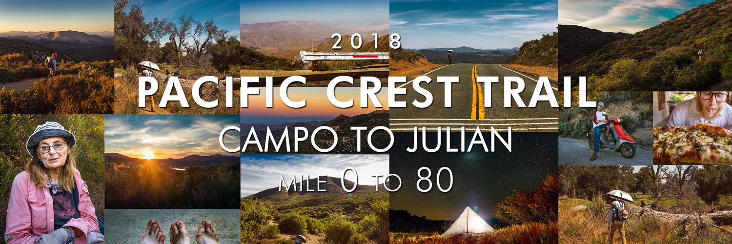
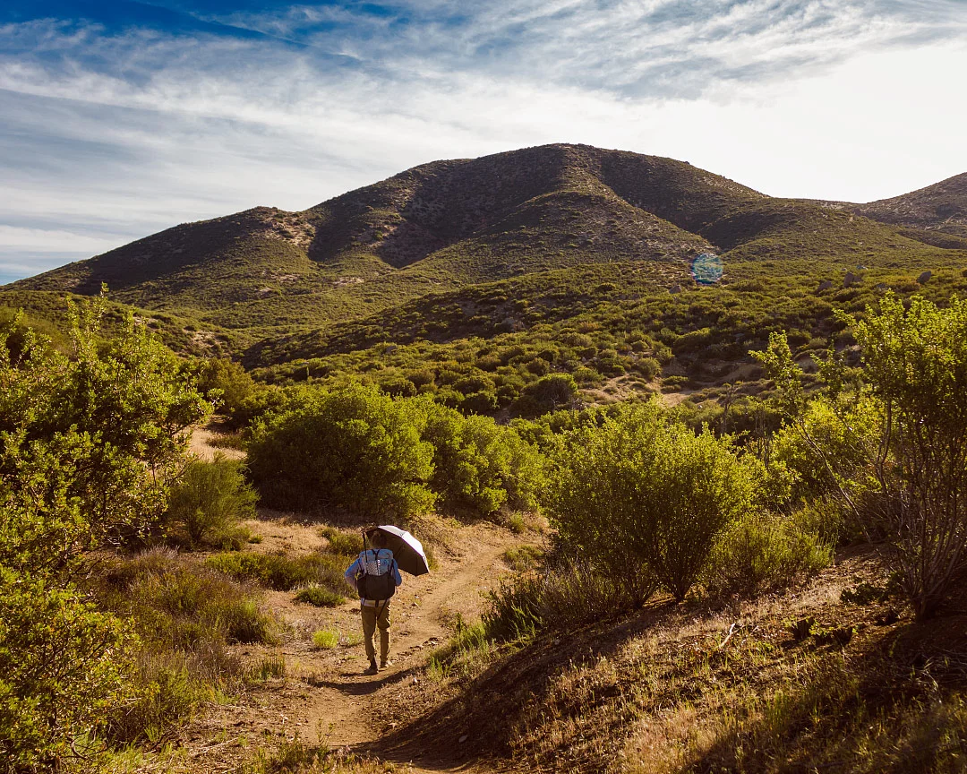
PCT 2018: Days 1-4, Campo to Julian
Photos and stories from my thru-hike of the PCT. This post covers days 1-4 from Campo to Julian, mile 0-80.
May 5, Day 1
20.5 miles [20.5]
I am absolutely stunned at how beautiful it all is. Met Ian and got my portrait taken, he says he'll be at the northern terminus sometime in October. Twenty minutes into our hike, we crossed the first of many milestones; mile-marker 1. It was hard not to smile. Two miles in, we double-backed into Campo for water. I later realized Hauser Creek was 15 miles away and the two liters of water I initially brought wasn't even going to last 10 miles. Saw a dozen or more hikers and found myself jumping to conclusions about their abilities. They probably knew about the lack of water sources though. Before Morena Mountain, we met “Charlie”, a weathered man on a motorbike. “You guys know you're crazy, right?” We chuckled and declined his offer for water—that lesson already learned. Adam seemed to be a wizard with Guthooks; kicking myself for not trying it out sooner. “The malt shop closes at 8 p.m., that's my goal” he said dryly as the sun was setting. At 7:59 p.m., we arrived wet and tired. Split a shake and french fries. Can't help but think this wasn't 'deserved'. Today was a butt-kicker, I've got to remember to drink more water—take care of yourself.
Adam basks in the glory of mile 1.
Railroad tracks, mile 3.
“Charlie”, somewhere near Morena Mountain.
Sunset over Lake Morena, mile 19.3.
May 6, Day 2
19 miles [39.5]
First full day on-trail! It got intensely hot quickly; tomorrow we're going to need to start earlier. A few miles in we stopped and chatted with a woman who introduced herself as “Nona From Nowhere”. She waved a bag of peanuts still in their shells at Adam and I. “You guys got names yet?” We shook our heads, smiled, and introduced our real names. “Hey Illinois, want some peanuts?” she said to Casey, the girl we'd been leapfrogging all morning. A big grin covered her face, “you know, I'm a Triple-Crowner,” she said wryly. “I angel a little bit up in Vancouver—you'll see me later.” She bid us a safe journey and we thanked her for the peanuts. The rest of the afternoon was rather uneventful. In the evening, when I went to put away my umbrella, I was stunned to find my second hiking pole was missing. It must have snagged on a branch and been stripped from my pack. My music was far too loud to have heard anything. Adam and I double-backed for more than a mile to no avail. Bummed to have lost a piece of gear so early, but I can't imagine a day when I won't need the umbrella. For now, #onepolepatrol.
“Nona from Nowhere”, has hiked all three long-distance trails in North America.
Adam near Cottonwood Canyon, mile ~24.
Kitchen road, mile 30.2.
Sunset over Troy Canyon, mile ~38.
May 7, Day 3
20 miles [59.5]
Started the morning strong with a Snickers bar. Made it to Pine Tree Lodge for some biscuits and gravy and a fresh espresso—I couldn't resist. Briefly stopped at the Mount Laguna general store; got a Budweiser and some chips. What a quaint little town. Today was also my first trail magic! At Roadside Lookout, we met Andrew and Jamie, who gave us ice-cold sodas and regaled us with stories of just how bad Scissors Crossing was going to be. Got moving after a nice long break, cool breezes made today tolerable. Filled up water and crushed the beer at Penny Pines Point; this carry has to last until Julian tomorrow—28 miles. After the sun had set, I took of my shirt for the last few miles of the day. Refreshing evening air filled the canyon as stars slowly began to appear.
Kwaaymii Point, mile 53.3.
Sunset over Granite Peak, mile 56.5.
Oriflamme Canyon sunset, mile ~57.
Sunrise trailhead campsite at night, mile 59.5.
May 8, Day 4
20.9 miles [80.4]
I'm getting better at waking up earlier; today we started hiking at 6:40 a.m. Although it seemed like there was only a few hours of tolerable hiking weather before it got insanely hot. The entire slog to Scissors Crossing was novelty-hot. My water tasted about 95 degrees. Every few miles I saw a full, unopened Lifewtr, each bottle scrawled with “the desert is a cruel bitch” in Sharpie. There were rumors of a guy who didn't carry enough water and had to turn back—apparently these bottles were his offering. Finally we made it to Scissors Crossing, I Was nervous how my fist hitch was going to pan out. Five minutes later, we were zooming into Julian with our new friend, “Monica from Santa Monica”. Hikers in town said pie couldn't be missed; but we opted for jalapenos and sausage at Romano's instead.
Near Julian, California, mile ~63.
Romano’s Pizza in Julian, California.
Dirty, blistered feet.
Hike On?

PCT 2018: Days 9-12, Mike's Place to Cabazon
Photos and stories from my thru-hike of the PCT. This post covers days 9-12 from Mike’s Place to Cabazon, mile 127-211.

May 13, Day 9
18.4 miles [145.4]
Today sucked. Why does life seem so much harder for me than everyone else? Stupid. We woke up in the clouds at Mike's, everything was soaking wet—in the desert. I hastily tried packing the tent only to end up arguing with Adam about something minor and borderline meaningless. Didn't manage my calories well at all and me knees bothered me the whole day. The cloud cover didn't even last long. By 9:30 a.m. I was sweltering once again. Adam made a call home in the afternoon, and somehow, I ended up talking with Mom. Exhausted and dripping, I was curt and rude. Fuck. I hate the phone. I'm so tired of being a goddamn weather-vane of emotions.
Beavertail pricklypear cactus.
Chihuahua road, Lost Valley, California, mile 127.3.
May 14, Day 10
6.4 miles [151.8]
Today we hiked with a group we had been seeing on and off the past few days. This morning, Ryan, Mitchy, “Mio”, Erin, Adam and I all woke soaking wet having cowboy-camped at “Mary's Water”, another morning in a cloud. I was legitimately cold last night. Everyone swiftly got moving, I was the last person to fully pack up. Mood was much better today, I was motivated for town and a burger at Paradise Valley Cafe. It was a short hike to Highway 74 where the owners gave us a hitch back to their cafe. I ended up going with biscuits and gravy and a beer. Very contented, very happy. Knee hurt, but a low-mileage day was helpful. Hitched into Idyllwild; I volunteered to sit shotgun and keep the driver company. Purchased a group campsite, laundry and coin-op showers, more beer and snacks, and a full resupply—five full days worth. Dinner was chili with Fritos and real cheese. What a fun group.
Erin hitching to Idyllwild, mile 151.8.
Adam at Mt. San Jacinto Park.
May 15, Day 11
12.7 miles [186.6]
Spent the morning trying to sleep in with little success. State campgrounds are never going to be quiet. The gang lazed around in the shade and rested up. I medicated with a few Budweiser's. We left Idyllwild in the afternoon and took the Deer Springs trail towards Mount San Jacinto—our goal was sunset on the peak. I now understand this means I skipped 31.7 miles of trail. I knew it had been closed due to fire, but I didn't realize our group didn't plan on going back for the alternate. Note: this doesn't feel great. I should take great caution if I feel the need to do this again. Found myself missing PCT-grade trails and was generally pissed most everyone is faster than me. However, the summit views were intense. Gorgeous, rich hues filled the hazy valley; Palm Springs glowed like a dull ember. We made a hasty camp and cooked Knorr garlic shells by headlamp. “Mio” wants to leave by 3:45 a.m. Ugh.
Adam scrambling on San Jacinto peak.
Deer Springs trail back to the PCT, mile ~183.
Sunset over San Gorgonio mountain.
Sunset over Santiago peak.
The city of Palm Springs, California lit up at dusk.
May 16, Day 12
25.1 miles [211.7]
My alarm rudely went off at 3:30 a.m. I quickly found myself towards the back of the pack during the long, grueling slog down Jacinto. As painful as it was, “Mio” was right—we needed all the time we could get. More than nine hours of descent, my legs are dead. Yesterday we added Darby, to our hiking group. While we waited, rested, and snacked at the water faucet, she taught us “hinky-pinky”, a rhyming word-game. Lots of laughs. Regrouped, we made tracks for Interstate 10. Four miles through sand into a forceful headwind made for rough hiking. We crossed under the overpass and found trail magic! We met Ken, a hopeful hiker for 2019, who offered to drive us anywhere we wanted. Everyone nodded in unison at the idea of In-N-Out in Cabazon. After snarfing down a couple double-doubles, we piled back into the pickup bed and tried to look inconspicuous. I split up an 18-pack of beer; three cans weighs too much. We ended a few miles away from the highway, resulting in my new longest day—25 miles.
Sunrise on Fuller Ridge, mile 187.5.
Descent off Mount San Jacinto, mile ~191.
Seeking shade in the California desert, mile ~196.
A distant San Gorgonio mountain, mile ~195
Mount San Jacinto, north of Interstate 10, mile ~211.
Interstate 10, mile 209.5.
Sunset on Mesa Wind Farm, mile 211.7.
Hike On?

PCT 2018: Days 13-16, Cabazon to Big Bear
Photos and stories from my thru-hike of the PCT. This post covers days 13-16 from Cabazon to Big Bear, mile 211-266.

May 17, Day 13
17.3 miles [229.0]
It wasn't a bad dream, our shelter blew down before dawn—it sounded like a tornado. Capitalized on the misfortune and got an earlier start. Once again, “Mio” lead the charge while the rest of us tried to keep up. Entered Section C and was blown away by the views. Angular piles of rusted rock among dozens of agave species surrounded me. At the Whitewater Preserve junction, we found a note from “Mio”. He has always been trying to catch his friends; it was only a matter of time before he split. I sincerely hope I see him again. We celebrated in his honor by taking a long siesta at Whitewater River to beat the midday heat. Everyone dropped down to their skivvies and took a refreshing dip. We played spades and passed around Adam's small flask of vodka. I won by going nil on the last hand—a real dirty move! Left and busted out another nine miles before dinner. Knee hurt, but not nearly in the same way it has the past few days. Improvement.
Ryan in the San Gorgonio Wilderness, mile ~223.5.
Erin crossing Whitewater River, mile 220.1.
San Jacinto peak near Whitewater River, mile 221.5.
Sand to Snow National Monument, mile ~217.
May 18, Day 14
19.7 miles [248.7]
Gang wanted to wake at 4 a.m., but when my alarm went off no one was moving. Dozed for another hour then got moving. Followed Mission Creek up a canyon for 10 miles. Tons of elevation but a few clouds made it tolerable. Took another 4-hour lunch break to avoid the heat, hydrate, and play more spades. Darby shared her kippers with me at lunch; I might have discovered a new item I can pack out. It paired well with a dollar lemon pie and several spoonfuls of peanut butter. Lots of laughs with Ryan and Mitchy; I'm still amazed we get to hike with another pair of brothers. Stoked for Big Bear tomorrow. Stinky, grimy, sore feet, but my knee's feeling good.
Looking towards Sugarloaf Mountain, mile ~241.
Cooking dinner on trail, mile 244.7.
Erin at Mission Camp, mile 239.9.
Adam at Mission Camp, mile 239.9.
Sand to Snow National Monument sunset, mile 248.7.
May 19, Day 15
17.4 miles [266.1]
Managed 17 miles to Highway 18 on very little food. Grandma's cookies, a packet of ramen, and a tortilla—I was running on fumes. At the Highway I met “Jitterbug”, a thru-hiker from '16 who cooked us tacos. Said our thanks and hitched into Big Bear where we all agreed on more Mexican food. Darby and Mitchy split a vegetarian “Big Juan”—a 7-pound burrito in less than 45 minutes for a free T-shirt. We were all a few pitchers of margaritas in and they had only made it halfway. The hostess kindly reminded everyone a man ate two in the allotted time. We digested and played spades covered by a small sliver of shade in the parking lot and waited for “Mountain Mama”. Her and “Papa Smurf” are trail angels who have opened up their house to hikers. I'm glad we had their contact info for a place to sleep. Otherwise, I had drawn the short straw to rent a U-Haul under my name for the next two days. Town is huge, I certainly don't remember it being this expansive on our family trips all those years ago.
US Forest Service trail sign, mile 259.6.
Ryan engages in full hiker-trash, Big Bear, California.
May 20, Day 16
0 miles [266.1]
Got a decent night's sleep for being directly under a streetlight. It was a slow morning, we played cards to pass some time. Our parents arrived and showered us with love and food. I sent back a camera lens. We went to an authentic German deli for lunch, their potato salad was unreal. I spent about 45 minutes after lunch calling Sprint trying to unlock my cell phone from the previous owner. Jesus Christ, I'd rather be hiking. We regrouped with our hiking family and piled in our car for a resupply at the Dollar Tree. Back at the house, we said our love-you’s and thank-you’s and watched our folks drive off. I overheard someone say the toilet was “severely clogged”, a few hikers who had arrived that morning seemed uncomfortable about the situation and began to leave. I saw “Mountain Mama” high-tail it into through the front door with what I later confirmed to be a drain snake. With absolutely zero experience, Adam and I politely took over. Two YouTube videos later, we were trained experts in home plumbing. I luckily fished out a rogue Dixie cup from the wreckage. We cleaned up everything, going through an entire roll of paper towels in the process. It was stressful and exhilarating to say the least. “Papa Smurf” returned home and quickly relaxed. Zero days are weird; I can’t wait to get hiking again. Knees feel good!
Mitchy and dog from Big Bear, California.
“Trash Bath” shows his Pop-Tart likeness.
Hike On?

PCT 2018: Days 22-25, Wrightwood to Agua Dulce
Photos and stories from my thru-hike of the PCT. This post covers days 22-25 from Wrightwood to Agua Dulce, mile 376-462.
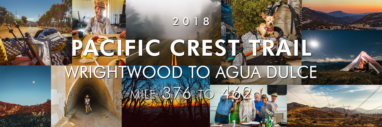
May 26, Day 22
19.7 miles [395.9]
Slept in until 7:15 a.m. fully aware we had to climb the remaining 1,000 vertical feet of Mount Baden-Powell. Met some nice people at the summit and took a relaxing breakfast stop. More gorgeous clouds today but my knees and feet are shot from the sheer amount of ups and downs. Passed by what felt like 100 Scouts headed towards Little Jimmy campground; I remember camping there as a young boy with my Troop. Crossed back and forth over Highway 2, eventually taking Buckhorn detour and roadwalking for nearly three miles. It was completely overcast. Occasionally a patch of clear would appear, quickly gobbled up by the moving mist. Heavy clouds filled the foothills below and trees above. I wore my puffy for most of the afternoon. Found some magic at Islip Saddle; Doritos, brownies, and some lavender-flavored after-dinner mints whose flavor had me contemplating if there was any food I wouldn’t eat. We walked through a very full Cooper Canyon, a popular campground for local Angelenos. A family enjoying their campfire saw us quietly walking by. “What you got in those bags?” asked the mother pointing at our backpacks Corona in hand. Adam and I smiled at each other. “Everything” doesn’t mean the same thing to weekend warriors.
Islip saddle, mile 386.1.
Highway 2, Angeles Crest, mile 389.3.
May 27, Day 23
25 miles [420.9]
It’s hard to believe we got trail magic on four separate occasions today alone. First was at Camp Glenwood where we met Maxx, who welcomed us inside with chocolate chip pancakes and fresh strawberries. Adam let me steal a spoonful of peanut butter. Maxx spied my Philmont ball cap, which I had switched out in Big Bear, and asked if I had been to the Ranch. I smiled big. We talked about his trek, the flood, and amazing staff. Next, we made it to Three Points junction and met JT, a thru-hiker from 2014, who tossed us both a PBR. Didn’t even make it three miles before magic spot number three; a stash of craft beers in the shade of a magnificent Douglas fir. Miles melted by. Just when I thought it couldn’t get better, we were graciously provided with dinner by a couple who are planning on hiking next season. They had an easy-up at Mill Creek Fire station and all the sandwich accoutrements. I made a chicken-avocado-cheddar and washed it down with a Coke. To top it off, they even knew about Philmont—their kid went on trek. We thanked them until it became borderline uncomfortable. Did two more miles and set up camp under a nearly full moon. Maybe it’s all the beer I drank, but it was hard not to think about the Ranch.
Moon rise over Angeles Crest Highway, mile 418.6.
Sunset at camp, mile 420.9.
Strawberry peak sunset, mile 418.6.
Pancakes at Camp Glenwood, mile 400.6.
May 28, Day 24
24.1 miles [445.0]
Greeted by another stellar desert sunrise upon waking. Temperature hovered in the high 90's all day which made for tough hiking. Pushed 15 miles to the North Fork Ranger Station where I refilled water, bought a Coke, and did extensive feet-maintenance. I could have sat there in the shade all afternoon. Another eight miles to the Acton KOA which offered $10 showers and frozen treats. Couldn't wrangle a deal with the attendant so I settled for a chocolate Dove bar and decided another spigot foot wash was all I needed—the 'off-limits' pool called my name the entire time. Marginally refreshed we began to hike out, only to be stopped by a pair of couples dining alfresco in the RV section. “You guys hungry?” they yelled as we walked by. We smiled, I still feel awkward accepting such benevolent charity. We sat and ate kebabs and pasta salad, everyone shared camping mishap stories. They insisted we take a bottle of wine and Perrier and beamed when I called them “Trail Angels”. My outlook on the day has changed; fellowship is more renewing than a hot shower.
Camping above Soledad Canyon, mile 445.0.
Trail magic at Acton KOA.
May 29, Day 25
17.6 miles [462.6]
Up at 5 a.m. and to no surprise it got hot almost immediately. Luckily the terrain was fairly easy into Agua Dulce. Vasquez Rocks was worth a return trip. Bought a strawberry Arizona iced tea and hitched in a truck bed over to Hiker Heaven to wait out the midday heat. “Numbers” gave us the run-down, I signed up for a shower and laundry immediately—it had been over two weeks. I lazed around in the shade with other hikers, sipping on the bottle of white wine we got yesterday, and talked about surviving for nearly 500 miles. Got drunk pretty quickly since I had only eaten a few snacks. Refreshed, we went back into town for resupply. Adam and I gorged ourselves on an eight-piece fried chicken dinner and a bagged kale salad from the deli counter. Pumped for Casa de Luna tomorrow, I’ve heard it’s an iconic location in trail culture. My clothes smell fresh, I am clean, I have food. Life’s good.
“Tiny” the dog at Hiker Heaven.
Highway 14 tunnel, mile 451.1.
Truck bed views near Agua Dulce.
Petersen road power lines, mile 456.6.
Hike On?

PCT 2018: Days 26-30, Agua Dulce to Tehachapi
Photos and stories from my thru-hike of the PCT. This post covers days 26-30 from Agua Dulce to Tehachapi, mile 462-570.

May 30, Day 26
17.6 miles [478.2]
It was wonderfully cloudy this morning, I still don’t have any idea what to expect in the desert. Enjoyed the misty hike into Green Valley with only one minor knee flare up, then immediately beelined for Heart and Soul Cafe where I devoured a club sandwich and iced Americano. Strolled into Casa de Luna and was immediately won over by the atmosphere. While I was donning my obligatory Hawaiian shirt, “Smokey”, a hiker who looked like he’d been vortexed a few days, introduced himself along with the house rules while simultaneously handing me a freshly packed pipe. I obliged and didn’t bother asking him how he got his name. I found Terrie and made sure to give her a hug—the first of 10 rules. Played some frolf with Adam in the manzanita forest while drinking beer from the gas station. I agreed to stir the nacho cheese to help with dinner prep. Also in the kitchen stirring beans was “Metric Ton”, a curious fellow whose name is derived from his base weight. But the biggest surprise of the day was discovering “Mio” is spending the night! Hippie Daycare exceeded all expectations.

Adam takes a snack break.
Shafts of light penetrate the deep scrub on a misty morning, mile 464.
A foggy, mysterious trail, mile 464.
Power lines over Sierra Pelona mountains, mile 463.8.
May 31, Day 27
25.9 miles [502.1]
Slept decently well at Casa de Luna. As promised, Joe made pancakes for all of us hungry hikers. I was slightly hungover and nursed some coffee. Last night's discussions and gossip about other hikers and the Sierra quickly resumed. Everyone gathered and we danced for Terrie in order to earn our PCT Class bandanas. During my “performance”, I sultrily unzipped my puffy and flung it from my body. Somehow it found the one nail on the garage door and hung itself absolutely perfectly. The crowd burst into raucous laughter. Just before heading out Terrie orchestrated a group photo, one which we'll all remember forever—photo or not. On trail we caught back up with “Mio” who's hiking with his buddy from the military. Just as dusk settled in Adam and I crossed the 500 mile marker. I would have felt more accomplished but something's clearly bothering him and I can't tell what. We talked poorly a few times. Found myself getting irrationally angry. What have I done?
500 mile marker.

Rock texture.
June 1, Day 28
27.2 miles [529.3]
The wind was so strong we took down our tent only 13 minutes after turning out the lights. It was a rough night of sleep. Fifteen miles of this morning’s descent weren’t any less gusty. Thought Adam was ahead of me and played catch-up for two hours, only to make it to Highway 138, completely alone, engulfed in a shadeless desert I had absolutely no desire to be in. It was 95 degrees. It’s June. I’m not even one-fifth done. I let out a heavy sob, one which I had been holding since May. Fuck this desert. Twenty minutes later, he showed up. I felt stupid. We took a long rest in Hiker Town, a poop in a real toilet got rid of a few demons. After trying to get a quick doze in, “Horny Toad” drove the communal Chevy Astro to Neenach Cafe. Somehow this place served hand-formed fresh burgers. I washed one down with a Manzanita Sol and a cherry Coke. Per usual, I didn’t have a plan for the upcoming terrain. Apparently this is the hottest, hardest section. Adam suggested we leave at 6 p.m.to take advantage of the night. Lot of other hikers seemed to be doing the same. We managed just shy of 12 more miles, stopping only for a positively stunning cloudless sunset and tuna taco dinner. We set up camp at 11 p.m., I’m utterly spent, I just feel annihilated.
Leaving Hiker Town, mile 517.6.
Clarkia cylindrica, speckled fairyfan.
Dirt road into Hiker Town, California, mile 517.
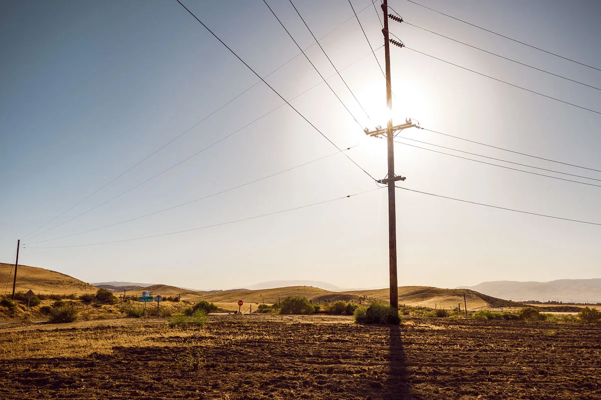
269th St. W, 517.6.
LA Aqueduct, mile 520.9.
June 2, Day 29
28.7 miles [558.0]
Woke well before dawn, hell, it was still night. Sunrise came quickly, illuminating thousands and thousands of turbines, all whirring and humming away. When it wasn’t being whipped around, my umbrella blocked most of the views. Mazama Wind farm was lonely, nothing but winding, scrubby hills filled with ghostly pinwheels. After 20 brutal miles, the desert gave us some respite—Mile 549 Bar and Grill—trail magic. I guzzled a blue Squeezit, straight from my childhood, hoping it would somehow transport me back. “Hard Time” seemed to be enjoying himself, every time I passed him he was Snapchatting. Ripped off the band-aid and left. Another eight miles made today our longest yet. Adam was melancholy and despondent the whole time. “I can’t keep doing this”, he told me at dinner, “I can’t be responsible for anyone.” I didn’t know how to respond. Am I burdensome? I don’t want to do this by myself; I want someone to share it with. What a gross thought. The turbines seem even louder at night, buzzing like low-pitched mosquitoes. The desert was so hard today.
Mazama Wind Farm sunrise, mile ~534.
Adam at Mile 549 Bar and Grill, mile 549.
Wind turbine, mile ~539.
Sawmill, Bootleg, and Quail canyons, mile 556.4.
June 3, Day 30
12.8 miles [570.8]
Woke from my bad dream not feeling any better. An overwhelming feeling of “useless, goalless, aimless” filled my entire being. It would have been easy to sit and wallow, but I tied my shoes tight and tried to pull it together. Made it through eight more miles of wind farm before reaching the highway, thankfully it was all downhill. Got a hitch and after relocating from a BBQ joint, found ourselves at a trusty McDonald's. One large iced coffee and impassioned internet search later, I purchased my own tent. Well, Adam did, now we’re square on that camera debt. Did a resupply at Albertsons and Dollar Store as well as coin-op laundry. Even found time to crush a Hot-N-Ready. Ran amok, we probably did five miles in town. Found an angel, Jeff, offering rides back to the trail. He’s only been doing it for three weeks but already helped out nearly 200 hikers. Hard slog up and away from the highway in some of the strongest wind I’ve ever experienced. Hunted a few miles for a shielded place to cowboy—hopefully this little bush helps.
Sunrise leaving camp, mile 558.
Desert signage, mile ~559.
Leaving Highway 58, mile 567.8.
Alta wind farm sunset , mile 568.9.
Hike On?

PCT Thru-Hike: Gear Review – What Worked, What Didn't, and Things I Would Change
In 2018, I thru-hiked of the Pacific Crest Trail. In this blog post I will share my thoughts and give a thorough review of the gear I used. Here’s where you can see all my PCT articles, including my daily journal and photos.
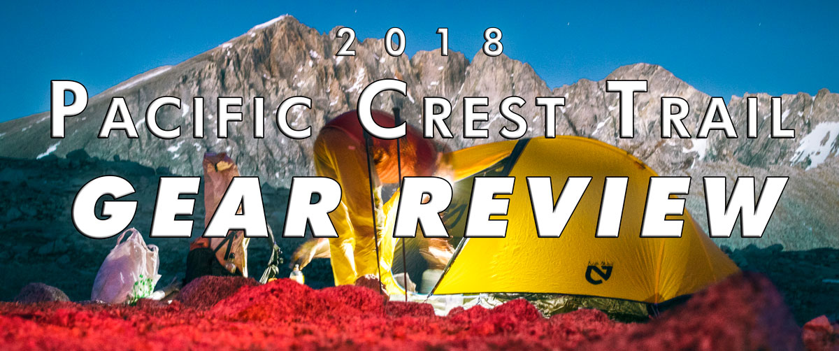
In 2018, I thru-hiked of the Pacific Crest Trail with my brother, “Shocks”. This was the first long distance hike for either of us; we learned a ton about gear, what ‘ultralight’ means, and how to make miles. In this blog I will share my thoughts and give a thorough review of the gear I used on the PCT.
Other Blog Topics
Weight Distribution
Gear is probably the most frequently discussed topic other than water conditions and how many miles you plan on doing that particular day. After all, if the only things you own are on being carried on your back, you think about them constantly. Not in a materialistic way, more in a practical way. “How can I carry less? What can I cut out? How do I see more and spend less?”
After about 1,000 miles of hiking (at least for me), you'll have some sort of epiphany and realize it all comes down to the level of comfort you're willing to sacrifice in order to lighten your pack. What “misery index” can you function at? This doesn't apply to all hikers, but most people I encountered had or grew into a lightweight mentality.
With that said, here's what I carried for the majority of my time, why I carried it, and what I would change on my next thru-hike.
(Click links below to jump to a specific section.)
Big Three | Clothing | Gear | Electronics | Miscellaneous
Big Three (Pack, Shelter, Sleep)
The “Big Three”, as they are commonly referred to, are the main items all hikers need. You have to carry your gear. You need shelter from the elements and for sleep. You need a way to stay warm at night. These are also the items which usually cost the most.
Pack: Hyperlite Mountain Gear Southwest 3400
A good view of my backpack crossing the border from California to Oregon.
BOTTOM LINE: Absolutely great pack. Probably better options out there with some personal testing, probably some user error on my behalf. Comfortable hip belt although the shoulder straps are a little sharp and rough. I have the first model with smaller hip belt pockets and didn't find them as horrible as some people talked about. Exceptionally water-resistant. 32 ounces.
OVERVIEW: A 55-liter cuben fiber pack with a decently padded hip belt. There are two metal stays in the back to give hold and shape. Billed as “100% waterproof” it lived up to expectations, though ultimately I didn't have enough days of rain to definitively say the pack was water-tight. It held out the dense fog and mist in Washington just fine. The side pockets can each hold two SmartWater bottles and the rear external pocket seemed just barely large enough most days. It seemed like the pack was designed to carry a maximum of 35 pounds. It can carry heavier loads, which I frequently did, but I started to notice tears where the hip belt attaches to the pack. It still functions great. I purchased it during Black Friday for 15%-off, totaling $345.
STORYTIME: I made a fairly big mistake when ordering my pack. They offer a few ranges of sizes, each one has a longer hip belt and slightly larger capacity, like 2-3 liters more for a large versus small size. I thought to myself “three extra liters sounds great” and found my 30-inch waist struggling to fill out a large hip belt. Completely my error. Please stop laughing. Cinched as tight as allowed, I barely had enough waist to keep my pack on my body, not accounting for the 20 pounds I was eventually going to lose throughout. I mitigated this with three sections of my Z Lite sleep pad stuffed around my hip belt. Another 'mod' which effected overall comfort was my camera which was attached to my left arm strap.
DO AGAIN?: Hard to say. For a thru-hike; probably not. They were one of the popular packs for 2017 and 2018, but there are so many different ultralight packs on the market to choose from. Ideally, I would downsize my carrying capacity to 35-45 liters. Hyperlite makes a 2400 which looks enticing. Many hikers had a ULA Circuit, but several complained of the padded mesh back not breathing well. It’s also 40 ounces. Friend “Combo” had a MLD Burn which looks great if you plan on carrying below 25 pounds—always. I would sacrifice a little comfort in my hip belt and overall capacity for a durable pack with comfortable shoulder straps weighing between 1-1.5 pounds. Best advice: try and wear a few options before making a purchase if you can.
ONE COMPLAINT: The pack does not have load lifters/adjustments which I found to be one of the biggest downfalls. I had to pull the arm straps tighter to compensate and they weren't particularly comfortable (especially with a 2-pound camera on my clavicle). It also becomes slightly ungainly and bulgy when the rollover portion is stuffed to the max.
Shelter: Big Agnes Fly Creek HV UL2
Nothing better than doors open when there aren’t any bothersome bugs.
BOTTOM LINE: A solid, generic approach to solving one of the biggest concerns on trail: shelter. The Fly Creek has a bathtub floor, rain fly, vestibule, and two zippers. I thoroughly enjoyed my nylon home, a sanctuary from mosquitoes and things that go bump. Billed as a “three season, free standing, ultralight tent”, it lived up to the hype. Ground cloth not included, I opted for Tyvek and cut a sheet weighing 6.6 ounces. 47 ounces total.
OVERVIEW: It also requires a lot of stakes to fully set up (nine), but you can get away with three or four while still using the rain fly and have a comfortable and mostly dry night. Using all nine got tedious, but it was very stable. Once set up, I felt completely safe and comfortable inside. I don't suffer from claustrophobia at all, in fact it was quite cozy. Because I had the two-man, I could fit my pack and all other gear inside the tent which was important on potentially wet nights. The tent is durable, but ultralight fabrics aren't meant to be treated like normal gear. I coddled the door zippers constantly, pulling both sides while pinching each side of the fabric closer.
STORYTIME: From mile 0-700—'The Desert'—Adam and I shared a tent. We were both pretty convinced sharing a massive tarp (a 'tarjp-mahal' if you will) for the entire trail was the best idea. We purchased a Hyperlite Ultamid 4; a 9-by-9 cuben pyramid weighing under 1.5 pounds which sets up with hiking poles. Throughout the desert section, we set up that shelter less than a dozen times, opting to 'cowboy' under the stars most nights as most people do. The plan was to also purchase the interior bug net for the Sierra, but Adam quickly realized spending every night a foot away from each other was going to get rough. He had his Nemo Hornet 2P sent from home and I purchased the Fly Creek in Tehachapi for a delivery to Kennedy Meadows South. After the desert, mosquitoes became so persistent I couldn't imagine not having a shelter to seek refuge. Once bugs stopped becoming a pervasive issue, rain became the next threat. Don't expect any dry nights in Washington. Just because you went to bed with clear skies doesn’t mean they will hold until morning.
DO AGAIN?: I would get a Zpacks Duplex or a Mountain Laurel Designs SoloMid XL for any long distance hike. They are significantly lighter, both requiring the use of hiking poles for setup. Since I carried a hiking pole(s), it makes more sense to me to lose the weight of tent poles. However, I will continue to use my Fly Creek until it breaks. I've had great luck with Big Agnes' return policy and I'm a customer for life.
ONE COMPLAINT: The vestibule zipper was a nuisance, it constantly caught on the flap of fabric intended to keep water out.
Sleep 1: Enlightened Equipment Revelation Custom
BOTTOM LINE: If you're new to quilts, this is a stellar, affordable solution. Durable and lightweight. Plus, it makes a great blanket. One of my favorite pieces of gear. So good it will make you a mummy-to-quilt convert. 30.7 ounces.
OVERVIEW: Quilts are a great, lightweight solution for warm sleep. There's less zipper and less fabric under you than a traditional mummy bag. The Revelation has a quarter-zip at the foot, giving it the option to lay flat or zip up around your feet. A few plastic clips along the sides help keep the quilt in a general taco-shape snapped around you and/or your pad. The top has a drawcord and snap to fasten around your neck like a snug jacket. I opted for a wide, 0-degree fill, red and black color, and purchased it on Black Friday for $288.
STORYTIME: Enlightened Equipment offers a zipperless sewn-footbox option—Enigma (stock $315, 21 ounces)—which seemed to be the most popular option on trail, especially for the ounce-counters. While shopping, I saw that a heavier 0-degree fill and 6 inches of extra width was going to cost about $60 more and weigh about 10 ounces more. The trade-offs seemed worth it, and now having completed the trail, I can say it was worth it to me. Plus, my brother got the exact same thing one year prior and I couldn't argue with his logic. Down provides instant warmth, something I was unaccustomed to having camped in synthetic mummies for nearly 20 years. When I cowboyed and my quilt got a lot of condensation, I made sure to dry it out in the sun during lunch before the next night of sleep.
DO AGAIN?: A big heck-yeah. Probably won't have to buy another sleep-system for many years because of how well it held up. Currently, I sleep with it in Breckenridge, Colorado. I think a down quilt, ultralight or not, will always be in my gear arsenal.
ONE COMPLAINT: That f&%$*#% draw cord was placed in the middle of the quilt. Cinched or not, the additional cord and toggle strangle, poke, and garrote you in the middle of the night. Someone, please, move it to the side in v2.0.
Sleep 2: Therm-A-Rest Z lite Sol
“Shocks” enjoying a peaceful lunch break.
BOTTOM LINE: Reliable and very easily replaced, cost-effective, decent R-value (2.6 for the Sol), durable. Bonus: ass-pad. 14 ounces.
OVERVIEW: A closed-cell foam pad, each of the 14 sections weighs one ounce and it never pops. Oh, and you don't have to inflate it each night or deflate it each morning. You just unstrap it from your pack and unfurl it like some sort of 90's T.V. goofball showing you photos of their extended family from their wallet.
STORYTIME: I thoroughly enjoyed not having to hyperventilate each time I wanted to go to sleep (inflating a pad). I cut off three sections and carried it: as my butt-pad, extra hip belt comfort and girth, and each night I put it under my hips for extra cushion. Over time, my hips and knees struggled to find a comfortable sleep position, but usually I was so tired I fell asleep in five minutes. At $45, you could buy two and swap out halfway. Inflatable pads looked nice, but they all seemed loud, slippery, pricey, and all have the potential to pop. And don't forget inflating and deflating every day.
DO AGAIN?: I could have suffered slightly more and carried far less, or carried slightly more and probably had far more luxury. I might go inflatable in the future to save on pack volume. Plus, any extra comfort for my knees and hips would be greatly appreciated. I probably wouldn't do closed-cell next hike, but I'm certainly bringing a butt pad.
SENT HOME: I started with a Big Agnes AXL Air, boasted as a sub-10 ounce inflatable. Adam's popped on night five. I coaxed mine until Big Bear (Day 15, mile 266), at which point I switched to the Z Lite for the remainder of the hike. Heard good things about Therm-a-Rest NeoAir Xlite and Nemo Tensor, but I opted to stay cheap and not upgrade.
ONE COMPLAINT: Therm-a-Rest, please offer an option 6 inches wider. I'm skinny but I don't sleep like Dracula; keeping all my body parts on the pad was a struggle.
Clothing
Being pale, ginger, and probably Irish, I was committed/sentenced to wearing long sleeves and pants for sun protection. Applying sunscreen multiple times a day didn't seem like a probable long-term solution, and after completing the trail, I stand by my original assessment. I managed to stay fully covered for the entire trail with exception for a few days in Northern California. Oh, and if you are as pale as me, sun gloves are probably a good choice. I didn't use them but kinda wish I did.
Shirts (Hiking):
BOTTOM LINE: After four shirts, the Nike Dry-FIT lives up to it's namesake by drying quickly and fitting snugly. Durable. Bonus: comes in a flattering shade of cyan for us gingers.
‘Shirt v1.0’ lasted miles 0-109.
‘Shirt v2.0’ lasted miles 109-1340.
‘Shirt v4.0’ lasted miles 1717-2652.
‘Shirt v3.5’ lasted miles 1340-1717.
STORYTIME: I started the trail in mid-2000 JCPenney 'Arizona' button down dress shirt. My thinking was, “it's gonna get destroyed, I'll just be that kooky guy with a weird shirt” which is totally acceptable in the hiking community.
At Warner Springs, California (Day 7, mile 109), and after learning what nipple chafe was due to some poorly placed embroidery, I walked into 2 Foot Adventures and got a RailRiders Sahara sun hoody. It was light—6 ounces—breathable, protective, comfortable on my nipples, and the hood alone meant I could now wear a mesh trucker hat instead of a wide brim. I never thought I would like a shirt so much. I probably appreciated it more after an entire week of struggling and sweating. This shirt lasted until Chester, California (Day 72, mile 1340). The shoulders were ripping and I was beginning to get sunburned. The only option was Dollar General which provided me a Hanes cotton T-shit. I purchased it, cut off the arms and hood from ‘Shirt 2.0’ which were still in good shape, and over the course of the next few days, sewed them onto my T-shirt. 'Shirt v3.5' was shaping up to be über trail-chic and functional.
This was not a permanent solution, nor was it meant to be, but it made me feel a lot better about hiking in the sun. Plus everything got the same shade of dirty, so no one really noticed the off-colored sleeves, not that I would have cared if they did. This fix allowed me to hike on to Ashland where I got 'Shirt v4.0'; a Nike Dry-FIT quarter-zip long-sleeve. Frankly, I wish I had started the trail in this shirt. It probably would have lasted the whole distance plus it was outright comfortable to wear. The high neck, and my now much longer hair, covered me very well allowing me to continue wearing a baseball cap. There also wasn't a whole lot of sun in Washington.
Pants (Hiking):
BOTTOM LINE: If you prefer to cover your legs, PrAna Brion are hands down the best choice. Plus, they are made with “Stretch Zion” which means high-legging over blow-downs is a breeze. They dry quickly and are surprisingly durable.
STORYTIME: I used two pair of pants. My first pair were the Brion which lasted until Ashland, Oregon (Day 88, mile 1,717). They were a size 30-30 and I used a 1-inch webbing strap as a belt, intended more for future utility. I finished the trail in Kuhl Renegade which were purchased at REI in Ashland.
I also packed board shorts. They weighed 5 ounces and were great for laundry days and my modesty, but ultimately, I could have ditched them entirely.
On Day 35 I noted in my journal that my clothes were starting to feel big. Over the next 40 days I got fed up. There were substantial rips on the inside seams from my ankle to mid-calf, mostly just from friction. Sometimes when walking the tread on my advancing step would catch the ripped inseam of my planted foot. I never fell, but after a few exhilarating stumbles, it seemed like a recipe for disaster. Plus, I had lost so much weight, they were bunched around my waist with my aforementioned webbing strap 'belt' and were outright uncomfortable; I needed a smaller size.
For a few untimely days after Chester, California through Hat Creek Rim (read: hot and exposed), I wore the aforementioned board shorts I had been carrying since mile 0. I pulled my boot-cut hiking socks as high as they would allow, making it a few days before a small band of sunburn developed below my knee. It was time to fix my pants. At Burney Falls State Park (Day 75, mile 1,419), I sewed up the rips, thus eliminating the 'danger' aspect from my pants. I cinched my 'belt' even tighter and coaxed them/myself to Ashland. My hiking group was planning an excursion to the famed REI, which seemed like an excellent opportunity to find a new pant solution.
I entered through the hallowed doors and struggled to find suitable pants in the Men's section. After a few laps of “I love my Brion's but 30's aren't going to fit me”, the kind associate showed my to the Kid's section. Fortunately, there was one pair of Kuhl Renegade in large which fit like a dream. I paid at the front and hell-to-the-yes I used my REI credit card for more dividends. Booyah. These pants worked out just fine, but I didn't enjoy them to the same level as my Brion's. The Renegade has two additional zippered pockets on the thigh which turned out to be amazing Pop-Tart storage locations. Sewing on the inseam and gusset as well as the knees started to fray after 500 miles, but they held up solid for the remaining 935 miles.
SENT HOME: I sent my Brion's home in Ashland. After the trail, I gained some weight, gave them a thorough wash, and they still fit and look great.
Shoes: Altra Lone Peak 3.5
Altra Lone Peak 3.5, the only two pairs of shoes I used for the entire trail.
BOTTOM LINE: Large toe box for us hikers with bunions. Zero-drop, if that’s your thing. Durable, but delicate toe-guard. Gaiters seemed useful for the desert.
STORYTIME: I'm not a shoe guy. All research seemed to point to Altra. I should have purchased them well ahead of time and broken them in, but alas, I didn't. After the first 800 trail miles, I didn't have any complaints and didn't want to switch brands or styles. With their inevitable failure ahead, I ordered my second pair in Bishop, California (Day 45, mile 831), and had them delivered home for request at a later date. Ultimately, I had them sent to Sierra City, California (Day 65, mile 1,950), exactly halfway from my finish date (who knew?). The second pair were a half-size bigger and I wore them until the end; two pairs of shoes for 2,800 miles of hiking. I purchased them through a Pro-deal membership, saving me about $60 in total.

My flip-flops weren’t even comfortable, but at least they weren’t shoes.
There was a lot of shoe-talk on the trail. Frankly, it was one of the topics I got tired of almost immediately. From the desert until Kennedy Meadows (Day 36, mile 702), everyone was trying figure out what shoe worked for them. I didn't understand the hikers who went through three pair before the 1,000 mile-marker. It seemed like their thought process was too neurotic. My brother liked to sarcastically joke, “Oh, your feet hurt? You must be thru-hiking!” I saw a lot of people change footwear, most likely because of sore feet. But at what point does one blame the shoe or walking 25 miles a day? And as for ‘blowouts’, I saw a ton of shoes in hiker boxes with PLENTY of great miles still left in them. A little rip or tread that's slightly worn still works great. But then again, those hiker's joints post-trail might be in great condition because they always had a fresh foot bed.
BACKUP: At Warner Springs (Day 7, mile 109), I purchased a $2 pair of shower sandals. They were useful for long lunch breaks where I wanted to air my feet out. They weren’t a complete necessity and I probably could have ditched them, but they came in handy on a frequent basis. I had space, so I kept them.
Jacket: Montbell Superior Down Parka
Wearing every single layer on top of Mount Whitney, California.
BOTTOM LINE: Exceptionally warm for sitting around camp, waiting for water to boil, and lunches in the shade. A hood was a necessity. 8.7 ounces.
STORYTIME: After months of searching for a Mountain Hardwear Ghost Whisperer and never finding it below $180, I decided to look elsewhere. I checked the outlet at Montbell and found the parka for 27%-off full retail. Down is a wonderful material and it kept me warm in critical situations on more than one occasion. I slept in it on cold nights, I wore it when I did laundry. But due to the price and fact it doesn't function well wet, I continually wondered how well a fleece layer would perform. After completing the trail, I'm not entirely sure if only a down jacket is the best solution. However, it’s light and warm and packs smaller than a 16 ounce water bottle; it’s going to be a regular item in my pack for future hikes. Back in Colorado, I wear it almost daily.
Rain Gear: Montbell Versalite
BOTTOM LINE: My only piece of dedicated rain gear. Blocked out wind and kept out rain. Infrequently worn; 6.4 ounces.
STORYTIME: I also bought this from the outlet and saved 32% off full retail. The zipper is not ideal; it has a lot of resistance and is sticky, but it keeps the water out. A nice addition were pit zips which I found myself using quite a bit through Oregon and Washington. Summers in New Mexico trained me for monsoon-like conditions, but the few rain storms I experienced were very mild.
Socks: Darn Tough
I carried three pair. Not only are they great socks, their return policy is unparalleled. I've worn Wigwam, SmartWool, Stance, but Darn Tough are now my go-to brand. In Mount Shasta, California (Day 79, mile 1,501), a local gear shop was doing a trade-in. I gave them my ripped pair in exchange for a fresh pair. Most hikers carried two pair. At good stream opportunities I would wash the dirtiest pair(s), weather dependent, which then became my hiking pair for the next day. The cleanest pair among the three were kept for sleeping. A lot of hikers chose lengths below mid-shin. I favored the longer boot cut variety.
Underwear: Exofficio Give-N-Go boxer-briefs
I carried two pair. They used to advertise “14 days on a single pair”, but most likely ditched that slogan because of how gross it sounded. No matter to me, I've been wearing them for years and can't think of anything else better.
Going commando is not my thing. The thought of not having that critical layer for friction and sweat does not sound appealing.
Base Layer/Sleep Clothes:
A lot of hikers prefer not to sleep in clothes but I hate the sticky-factor of dirty skin. Plus, clothing helps prolong the life your sleep system.
Additionally, I didn't know how cold I would be at night. I used an old pair of synthetic leggings but splurged for a SmartWool Merino 250 wool shirt. At 9 ounces for the top alone, it kept me warm but I probably could have gotten a synthetic layer for cheaper and lighter. Doing again, I would ditch the wool layer and get a fleece.
Additional Warmth:
A beanie was important especially as a young balding man. I wore a simple fleece beanie from childhood until around mile 2,460 where I think it fell out of my pocket. RIP.
A synthetic neck gaiter or Buff was a mission-critical piece of gear. On cool, damp mornings, it was like wearing a light jacket. At night, it worked great to keep the draft out and allow me to sleep without cinching my quilt tight.
Gear
You don’t need much as a thru-hiker; everyone has their definition of necessity. But here are some gear items which rank closer to mandatory rather than optional.
BEAR CANISTER: BEAR VAULT BV500
BOTTOM LINE: A requirement for Yosemite National Park. Good lord, I hated carrying this damn thing; 41 ounces. The only bonus is you have the perfect seat for 390 miles.
STORYTIME: Make sure your bear canister fits in your backpack. In my past experience, I’ve been able to carry a canister inside, horizontally. The BV500 only fits into the Southwest 3400 vertically with plenty of free space on the sides. This was a slight setback but ultimately I found a way to pack my clothes around the canister in order to provide some padding for my back. Plus, I didn’t have much choice; there wasn’t much room left with my quilt and canister packed anyway. I used a canister from Kennedy Meadows (South) until South Lake Tahoe. Lassen Volcanic National Park is the only other required zone; I didn’t camp there.
Gossamer Gear LiteFlex Hiking Umbrella

“Shocks” getting great use out of his umbrella. It’s like holding a latte for 700 miles.
BOTTOM LINE: There isn’t any shade in the desert; bring your own. I found an umbrella to be a mission-critical piece of gear. Solid construction. 8 ounces.
STORYTIME: An umbrella seems like a laughable thing to bring on a hike. It wasn’t. Most hikers got rid of their umbrellas at Kennedy Meadows, but I chose to keep mine for the entire trail. There were a few times I was waiting for a hitch in the scorching NorCal sun, cool as a cucumber under my portable shade. I used it a few times for heavier rain in northern Washington. Carrying an umbrella all day long isn’t ideal, but it was better than being exposed.
I head a hiker after Tehatchapai say, “I don’t think I’ve ever loved anything as much as my umbrella” with total sincerity. It was one of the most relateable statements I heard all trail.
ONE COMPLAINT: The handle didn’t seem long enough. An extra 6 inches would make all the difference.
Routa Locura Yana Carbon Fiber Poles
BOTTOM LINE: Feather-light, exceptionally durable, game changer in terms of trekking poles. Pricey, but worth it. 3.75 ounces each.
OVERVIEW: A two-section twist-lock carbon fiber trekking pole, straps are extra. Adam found these suggested on a forum when looking for ways to set up our Hyperlite shelter. Initially, I was skeptical at how a lightweight pole would perform over a thru-hike. I saw many other poles with blown out tips, most are easily replaced. After 2,500 miles, my tip finally broke off. It has a Black Diamond base, eventually I'll order a replacement tip.
STORYTIME: I was constantly shocked at just how little the poles weigh. You barely notice them in your hand. Hikers asked how I liked my trekking pole and I just smiled and handed it to them. Looks of incredulity and amazement always followed. It feels like a magic wand from Ollivanders. Because they were so lightweight, when I began to trip I could easily plunge one in front of me to keep from falling. Sadly though, on Day 2, I lost one due to poor placement on the outside of my pack (one hand for an umbrella). I finished the rest of the trail with my one remaining pole. #onepolepatrol
ONE COMPLAINT: The only downside to a pole this light was...how lightweight it was. Small shrubs and roots easily caught and snagged my pole in-stride which made it hard to plant firmly. It may sound trite, but imagine your walking stick not making contact with the ground every dozen steps. It gets annoying. The foam handle should extrude over the webbing between your thumb and index finger, like ski poles, for enhanced grip.
Water System: Katadyn BeFree and Hydrapak Seeker 3L
BOTTOM LINE: Great squeeze filter but short lifespan. Amazing and effortless flow-rate when it’s new, then slows to a crawl. Will save your life, but you’re probably going to die from squeezing before you get a full cup to drink. 4.2 ounces total.
STORYTIME: For the entire trail I used a Katadyn BeFree, three for that matter. Filtering performance is great for the first 30-50 liters, and then 50-100 becomes a patient wait. After that, the filter is very slow and irritating to use. I had to squeeze my Hydrapak for such a long time. I think my flow rate was 6-7 minutes per liter. Adam and I shared one on and off through the desert. At the beginning of the Sierra I neglected to sleep with mine and awoke to it covered in frost. I didn't want to take any chances with it’s efficacy. Adam graciously shared his with me until Bishop, California, where I purchased a second filter. It lasted, or rather I put up with it, until Ashland, Oregon, where I purchased my third filter. I finished the trail with that filter and it was slow going for the last 400 miles.
Shovel: Deuce of Spades
How can you resist? It has a bitchin' name and weighs 0.6 ounces. My LNT instructor had moded his handle with a small piece of leather. I used mine just fine, but the handle can be quite sharp when digging into hard and rocky soil. Ultralight Hack: ditch your spoon; the shovel is a great multi-tasker!
Electronics
Getting to disconnect is one of the best things about long distance hiking. But then again you’re probably going to have to carry some electronics, a phone at the least. But how you choose to use it is up to you.
Power: Anker 20000mAh QC3 compatible AC to USB power bank
BOTTOM LINE: Having quick-charge (QC3.0) was completely worth it. Many times I would spend half a day in town and leave the pack to charge. It was intended for two people to share; 13 ounces.
STORYTIME: Adam soon realized we needed our own so I kept it and he bought a smaller 10000mAh option. I didn’t want to spend $40 to lose six ounces, even though that was probably one of the cheapest ways to lose weight. However, this meant I could listen to podcasts with impunity. And sometimes when I didn’t feel like finding my flashlight, I used my phone’s light. And sometimes when I really didn’t want to know how far I hiked but I checked anyway, I had plenty of juice left until the next recharge point.
Flashlight: Petzl AKTIK Core Headlamp
BOTTOM LINE: A no-nonsense solution for having light where there isn’t any. It has firm angle delineations, is USB rechargeable, and has a red setting. Weighs 2.9 ounces.
STORYTIME: My only complaint was the price; $65. There are a lot of other solutions out there, don't get lost and overwhelmed reading Reddit. From a practical standpoint, I didn't use my headlamp all too frequently. Night hiking isn't really my thing; only one night (LA aqueduct) did I hike until 11:00 P.M. Mostly, I used it to cook at night and pack up during pre-dawn. I used the red light more than the white. If I were to do again, I would find a light with a higher red output. I was able to charge the headlamp from my battery pack.
Device: iPhone 7+
BOTTOM LINE: Lightning connector only. Way too big. And the lack of a g@#$!&@ headphone jack meant a lot of struggling to find appropriate earbuds. Decent pictures, 2-3 day battery life depending on how much screen time and GPS I used. Phone and case weigh 9.8 ounces.
STORYTIME: You’re probably going to want a phone for your trail experience. Using paper maps and reading water reports can be fun and challenging, but if you’re reading this review, that’s probably not your speed. A device to use apps like Guthook or Halfmile are a borderline necessity. I bought a lightly used iPhone 7+ from a third-party marketplace and slapped on an Otterbox case. I also went through three pair of earbuds and three Lightning-to-3.5mm adapters.
Camera: Canon Rebel Sl2
BOTTOM LINE: Great image quality in a reasonably sized body. Body, lens, mount, batteries, and charger weighed 29.5 ounces total.
OVERVIEW: To photograph my trail experience, I chose to use an APS-C DSLR. At the time of writing, Canon’s SL2 is the second-lightest DLSR on the market. I used an 18-55mm f/4-5.6 IS STM Lens for the entire time, even though I brought a 50mm f/1.8 and a 10-18
I mounted the camera to my left shoulder strap with a Peak Designs Capture 3.0 for easy access. I used two batteries, one third-party, and charged them with an OAproda Slim USB charger. I also bought an UltraPod III tripod, but found out it wasn’t entirely useful for the type of shooting I was doing. It got sent home in Kennedy Meadows.
Miscellaneous
And here’s the few other notable things in my pack. These don’t count as necessity but I’m very glad I brought them.
Sunglasses:
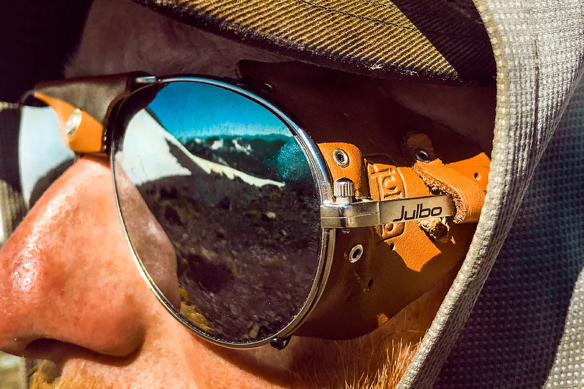
Julbo Cham sunglasses. Perfect for the Sierra.
Well, these are a necessity. As a photographer I'm spoiled and accustomed to great optics and glass. Having owned only one pair of prescription sunglasses, I decided to splurge on a new pair. Readers might get a sour taste in their mouth but I spent a disgusting amount of money on a pair of Julbo mountaineering style glasses. Most of that money went into custom mirrored prescription lenses from Revant. Although pricey, their service and product is sublime and worth every cent. With less than a two-week window, they rushed my order for delivery the day before I left. In total, I spent $350, $250 of that was for the custom prescription. I can confidently say this was a great choice.
Let me be clear; $20 can buy you a great pair of sunny's, which if taken care of, should last the entire trail.
Pillow:
Plenty of opinions out there as to if a pillow is worth it. This hiker says abso-freaking-lutely yes. I used the Nemo Fillo Elite which weighs 2.9 ounces.
It's relatively quiet and has a soft liner on the outside. One downside is it skids around at night if you are an active sleeper. I folded up my pants and shirt and put it under my pillow for added comfort.
Stuff Sacks:
I used two brands of ditty bags to keep various bits and bobs together in my pack. For my clothes, I used a Sea to Summit Ultra-Sil 4 liter. This barely held my board shorts, thermal top and bottom, two pairs of socks, undies, and a bandanna.
I also had Yama Mountain Gear dyneema bags. This was part of a DIY kit which Adam purchased. It made several little bags; I had three sizes. I used them for my toiletries, electronics, and wallet respectively.
Journal:
To journal all my thoughts in the evening, I used two Rite in the Rain top-spiral notebooks. The 4-by-6-inch size was a little small. Doing again, I would get a larger size.
Writing was the best medium for recording my memories. Typing into my phone worked, but it wasn’t the most productive. I typed random thoughts into the Notes application while I hiked.
Final Thoughts
Invest in good gear and it’ll take care of you; treat it well and it will last a long time. Almost everything I bought could be used for another thru-hike. From the above list, I only destroyed two pairs of shoes, three water filters, and two-ish shirts (frankly, I made one of them better), and my pack is well-loved.
Remember, gear isn’t everything. And you’re probably carrying too much.
About the Blog

Justin Kernes is a photographer and writer who thrives in the great outdoors.
From 2010-2017, he worked in the backcountry at Philmont Scout Ranch in New Mexico.
In 2018 “Tiny Slice” successfully thru-hiked the Pacific Crest Trail.
Search the Blog
Featured Posts


Photos and stories from my thru-hike of the PCT. This post covers day 111, Goat Rocks and my 30th birthday.